Schneizlreuth geodata
Schneizlreuth (Bavaria) is a seat of a fourth-order administrative division; located in Germany in Europe/Berlin (GMT+2) time zone. With population of 1,538 people, there are 5800 cities with bigger population in this country. Compared to other cities in Germany, 98.9% of cities are located further ↑North; 90.7% of cities are located further ←West and 96.7% of cities have lower elevation than Schneizlreuth. Note1
Administrative division(s):
- Level 1: Bavaria
- Level 2: Upper Bavaria
- Level 3: Berchtesgadener Land
- Level 4: Schneizlreuth


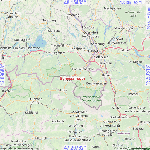
Schneizlreuth GPS coordinates[2]
47° 40' 59.988" North, 12° 48' 0" East
| Map corner | latitude | longitude |
|---|---|---|
| Upper-left | 48.15455°, | 12.09688° |
| Center: | 47.68333°, | 12.8° |
| Lower-right: | 47.20782°, | 13.50313° |
| Map W x H: | 105.3×105.3 km | = 65.4×65.4mi |
| max Lat: | 55.01917° ⇑98.9% North |
| Schneizlreuth: | 47.68333° |
| min Lat: | ⇓1.1% South 47.40724° |
| min Long | Schneizlreuth | max Long |
| 5.92978° | 12.8° | 14.98853° |
| W 90.7%⇐ | ⇒9.3% E |
Elevation
Elevation of Schneizlreuth is 651 m = 2136 ft, and this is 401.9 m = 1319 ft above average elevation for this country.
| Max E: |
1256 m = 4121 ft | 3.3% |
| Schneizlreuth | 651 m 2136 ft | |
| Avg. | 249.1 m = 817 ft | |
Min E: |
-5 m = -16 ft | 96.7% |
See also: Germany elevation on elevation.city.
Geographical zone
Schneizlreuth is located in North temperate zone (between Tropic of Cancer and the Arctic Circle). Distance of this North polar circle is 2099.3 km =1304.4 mi to North.| Distance of | km | miles | from Schneizlreuth |
|---|---|---|---|
| North Pole | 4705.2 | 2923.7 | to North |
| Arctic Circle | 2099.3 | 1304.4 | to North |
| Tropic Cancer | 2696 | 1675.2 | to South |
| Equator | 5301.9 | 3294.4 | to South |


Nearby cities:
15 places around Schneizlreuth: (largest is in red/bold)
• Ainring
17.8 km =11.1 mi,  36°
36°
• Anger
13.9 km =8.6 mi,  18°
18°
• Bad Reichenhall
7.8 km =4.8 mi,  48°
48°
• Bayerisch Gmain
8.4 km =5.2 mi,  63°
63°
• Berchtesgaden
16.1 km =10 mi,  110°
110°
• Bergen
21 km =13 mi,  311°
311°
• Bischofswiesen
14.9 km =9.3 mi, 112°
• Inzell
9.6 km =6 mi,  337°
337°
• Marktschellenberg
18.3 km =11.4 mi,  85°
85°
• Piding
12.7 km =7.9 mi, 43°
• Ramsau
10.5 km =6.5 mi,  134°
134°
• Ruhpolding
14.6 km =9.1 mi, 309°
• Schönau am Königssee
16.8 km =10.4 mi,  123°
123°
• Siegsdorf
19.5 km =12.1 mi,  322°
322°
• Teisendorf
18.5 km =11.5 mi,  4°
4°
Sources, notices
• [Note1] Compared only with cities in Germany existing in our database
• [Src1] Map data: © OpenStreetMap contributors (CC-BY-SA)
• [Src2] Other city data from geonames.org with taken over terms of usage.
• [Src3] Geographical zone / Annual Mean Temperature by Robert A. Rohde @ Wikipedia
