Bischofswiesen geodata
Bischofswiesen (Bavaria) is a seat of a fourth-order administrative division; located in Germany in Europe/Berlin (GMT+2) time zone. With population of 7,535 people, there are 2061 cities with bigger population in this country. Compared to other cities in Germany, 99.4% of cities are located further ↑North; 92.2% of cities are located further ←West and 96.1% of cities have lower elevation than Bischofswiesen. Note1
Administrative division(s):
- Level 1: Bavaria
- Level 2: Upper Bavaria
- Level 3: Berchtesgadener Land
- Level 4: Bischofswiesen


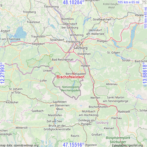
Bischofswiesen GPS coordinates[2]
47° 37' 52.14" North, 12° 58' 58.98" East
| Map corner | latitude | longitude |
|---|---|---|
| Upper-left | 48.10284°, | 12.27993° |
| Center: | 47.63115°, | 12.98305° |
| Lower-right: | 47.15516°, | 13.68618° |
| Map W x H: | 105.4×105.4 km | = 65.5×65.5mi |
| max Lat: | 55.01917° ⇑99.4% North |
| Bischofswiesen: | 47.63115° |
| min Lat: | ⇓0.6% South 47.40724° |
| min Long | Bischofswiesen | max Long |
| 5.92978° | 12.98305° | 14.98853° |
| W 92.2%⇐ | ⇒7.8% E |
Elevation
Elevation of Bischofswiesen is 633 m = 2077 ft, and this is 383.9 m = 1260 ft above average elevation for this country.
| Max E: |
1256 m = 4121 ft | 3.9% |
| Bischofswiesen | 633 m 2077 ft | |
| Avg. | 249.1 m = 817 ft | |
Min E: |
-5 m = -16 ft | 96.1% |
See also: Germany elevation on elevation.city.
Geographical zone
Bischofswiesen is located in North temperate zone (between Tropic of Cancer and the Arctic Circle). Distance of this North polar circle is 2105.1 km =1308 mi to North.| Distance of | km | miles | from Bischofswiesen |
|---|---|---|---|
| North Pole | 4711 | 2927.3 | to North |
| Arctic Circle | 2105.1 | 1308 | to North |
| Tropic Cancer | 2690.2 | 1671.6 | to South |
| Equator | 5296.1 | 3290.8 | to South |


Nearby cities:
15 places around Bischofswiesen: (largest is in red/bold)
• Ainring
20.5 km =12.7 mi,  351°
351°
• Anger
21.2 km =13.2 mi,  333°
333°
• Bad Reichenhall
13.5 km =8.4 mi,  324°
324°
• Bayerisch Gmain
11.4 km =7.1 mi, 326°
• Berchtesgaden
1.4 km =0.9 mi,  84°
84°
• Freilassing
23.3 km =14.5 mi,  359°
359°
• Inzell
22.7 km =14.1 mi,  310°
310°
• Marktschellenberg
8.6 km =5.3 mi,  31°
31°
• Piding
15.9 km =9.9 mi,  341°
341°
• Ramsau
6.4 km =4 mi,  255°
255°
• Ruhpolding
29.1 km =18.1 mi,  301°
301°
• Schneizlreuth
14.9 km =9.3 mi,  292°
292°
• Schönau am Königssee
3.4 km =2.1 mi,  174°
174°
• Siegsdorf
33.2 km =20.6 mi, 309°
• Teisendorf
27.2 km =16.9 mi, 333°
Sources, notices
• [Note1] Compared only with cities in Germany existing in our database
• [Src1] Map data: © OpenStreetMap contributors (CC-BY-SA)
• [Src2] Other city data from geonames.org with taken over terms of usage.
• [Src3] Geographical zone / Annual Mean Temperature by Robert A. Rohde @ Wikipedia
