Schirnding geodata
Schirnding (Bavaria) is a populated place; located in Germany in Europe/Berlin (GMT+2) time zone. With population of 1,471 people, there are 5937 cities with bigger population in this country. Compared to other cities in Germany, 61.9% of cities are located further ↑North; 85% of cities are located further ←West and 83.4% of cities have lower elevation than Schirnding. Note1
Administrative division(s):
- Level 1: Bavaria
- Level 2: Upper Franconia
- Level 3: Landkreis Wunsiedel im Fichtelgebirge
- Level 4: Schirnding, Markt


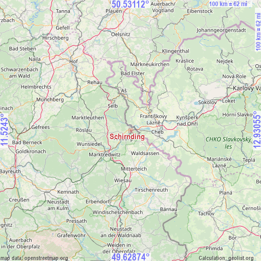
Schirnding GPS coordinates[2]
50° 4' 55.38" North, 12° 13' 38.712" East
| Map corner | latitude | longitude |
|---|---|---|
| Upper-left | 50.53112°, | 11.5243° |
| Center: | 50.08205°, | 12.22742° |
| Lower-right: | 49.62874°, | 12.93055° |
| Map W x H: | 100.3×100.3 km | = 62.3×62.3mi |
| max Lat: | 55.01917° ⇑61.9% North |
| Schirnding: | 50.08205° |
| min Lat: | ⇓38.1% South 47.40724° |
| min Long | Schirnding | max Long |
| 5.92978° | 12.22742° | 14.98853° |
| W 85%⇐ | ⇒15% E |
Elevation
Elevation of Schirnding is 457 m = 1499 ft, and this is 207.9 m = 682 ft above average elevation for this country.
| Max E: |
1256 m = 4121 ft | 16.6% |
| Schirnding | 457 m 1499 ft | |
| Avg. | 249.1 m = 817 ft | |
Min E: |
-5 m = -16 ft | 83.4% |
See also: Germany elevation on elevation.city.
Geographical zone
Schirnding is located in North temperate zone (between Tropic of Cancer and the Arctic Circle). Distance of this North polar circle is 1832.6 km =1138.7 mi to North.| Distance of | km | miles | from Schirnding |
|---|---|---|---|
| North Pole | 4438.5 | 2758 | to North |
| Arctic Circle | 1832.6 | 1138.7 | to North |
| Tropic Cancer | 2962.7 | 1840.9 | to South |
| Equator | 5568.6 | 3460.2 | to South |


Nearby cities:
15 places around Schirnding: (largest is in red/bold)
• Arzberg
4 km =2.5 mi,  227°
227°
• Bad Alexandersbad
16.7 km =10.4 mi,  244°
244°
• Bad Brambach
16.3 km =10.1 mi,  23°
23°
• Hohenberg an der Eger
1.5 km =0.9 mi,  340°
340°
• Höchstädt bei Thiersheim
10.2 km =6.3 mi,  282°
282°
• Leonberg
15.6 km =9.7 mi,  164°
164°
• Marktredwitz
13.3 km =8.3 mi, 229°
• Mitterteich
14.6 km =9.1 mi,  175°
175°
• Pechbrunn
13.5 km =8.4 mi,  198°
198°
• Schönwald
16.6 km =10.3 mi,  322°
322°
• Selb
12 km =7.5 mi, 324°
• Thiersheim
7.2 km =4.5 mi,  264°
264°
• Thierstein
9.3 km =5.8 mi,  286°
286°
• Waldershof
16.2 km =10.1 mi, 226°
• Waldsassen
10.5 km =6.5 mi,  148°
148°
Sources, notices
• [Note1] Compared only with cities in Germany existing in our database
• [Src1] Map data: © OpenStreetMap contributors (CC-BY-SA)
• [Src2] Other city data from geonames.org with taken over terms of usage.
• [Src3] Geographical zone / Annual Mean Temperature by Robert A. Rohde @ Wikipedia
