Waldsassen geodata
Waldsassen (Bavaria) is a populated place; located in Germany in Europe/Berlin (GMT+2) time zone. With population of 7,505 people, there are 2071 cities with bigger population in this country. Compared to other cities in Germany, 63.7% of cities are located further ↑North; 85.9% of cities are located further ←West and 86.9% of cities have lower elevation than Waldsassen. Note1
Administrative division(s):
- Level 1: Bavaria
- Level 2: Upper Palatinate
- Level 3: Landkreis Tirschenreuth
- Level 4: Waldsassen


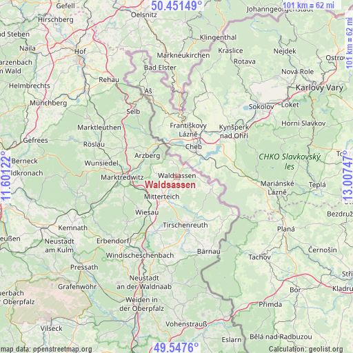
Waldsassen GPS coordinates[2]
50° 0' 6.012" North, 12° 18' 15.624" East
| Map corner | latitude | longitude |
|---|---|---|
| Upper-left | 50.45149°, | 11.60122° |
| Center: | 50.00167°, | 12.30434° |
| Lower-right: | 49.5476°, | 13.00747° |
| Map W x H: | 100.5×100.5 km | = 62.4×62.4mi |
| max Lat: | 55.01917° ⇑63.7% North |
| Waldsassen: | 50.00167° |
| min Lat: | ⇓36.3% South 47.40724° |
| min Long | Waldsassen | max Long |
| 5.92978° | 12.30434° | 14.98853° |
| W 85.9%⇐ | ⇒14.1% E |
Elevation
Elevation of Waldsassen is 485 m = 1591 ft, and this is 235.9 m = 774 ft above average elevation for this country.
| Max E: |
1256 m = 4121 ft | 13.1% |
| Waldsassen | 485 m 1591 ft | |
| Avg. | 249.1 m = 817 ft | |
Min E: |
-5 m = -16 ft | 86.9% |
See also: Germany elevation on elevation.city.
Geographical zone
Waldsassen is located in North temperate zone (between Tropic of Cancer and the Arctic Circle). Distance of this North polar circle is 1841.5 km =1144.3 mi to North.| Distance of | km | miles | from Waldsassen |
|---|---|---|---|
| North Pole | 4447.4 | 2763.5 | to North |
| Arctic Circle | 1841.5 | 1144.3 | to North |
| Tropic Cancer | 2953.7 | 1835.3 | to South |
| Equator | 5559.7 | 3454.6 | to South |


Nearby cities:
15 places around Waldsassen: (largest is in red/bold)
• Arzberg
10.5 km =6.5 mi,  306°
306°
• Falkenberg
16.9 km =10.5 mi,  199°
199°
• Fuchsmühl
14.3 km =8.9 mi,  232°
232°
• Hohenberg an der Eger
12 km =7.5 mi,  329°
329°
• Leonberg
6.2 km =3.9 mi,  192°
192°
• Marktredwitz
15.6 km =9.7 mi,  271°
271°
• Mitterteich
7.1 km =4.4 mi,  218°
218°
• Neualbenreuth
10.2 km =6.3 mi,  103°
103°
• Pechbrunn
10.6 km =6.6 mi,  248°
248°
• Schirnding
10.5 km =6.5 mi, 328°
• Thiersheim
15.2 km =9.4 mi,  303°
303°
• Thierstein
18.6 km =11.6 mi, 308°
• Tirschenreuth
13.4 km =8.3 mi,  171°
171°
• Waldershof
17.4 km =10.8 mi,  262°
262°
• Wiesau
13.3 km =8.3 mi, 218°
Sources, notices
• [Note1] Compared only with cities in Germany existing in our database
• [Src1] Map data: © OpenStreetMap contributors (CC-BY-SA)
• [Src2] Other city data from geonames.org with taken over terms of usage.
• [Src3] Geographical zone / Annual Mean Temperature by Robert A. Rohde @ Wikipedia
