Schönwald geodata
Schönwald (Bavaria) is a populated place; located in Germany in Europe/Berlin (GMT+2) time zone. With population of 3,741 people, there are 3443 cities with bigger population in this country. Compared to other cities in Germany, 59% of cities are located further ↑North; 83% of cities are located further ←West and 96.5% of cities have lower elevation than Schönwald. Note1
Administrative division(s):
- Level 1: Bavaria
- Level 2: Upper Franconia
- Level 3: Landkreis Wunsiedel im Fichtelgebirge
- Level 4: Schönwald


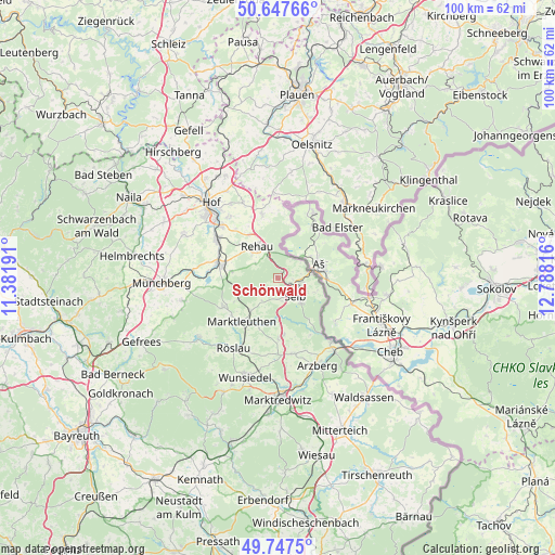
Schönwald GPS coordinates[2]
50° 11' 58.92" North, 12° 5' 6.108" East
| Map corner | latitude | longitude |
|---|---|---|
| Upper-left | 50.64766°, | 11.38191° |
| Center: | 50.1997°, | 12.08503° |
| Lower-right: | 49.7475°, | 12.78816° |
| Map W x H: | 100.1×100.1 km | = 62.2×62.2mi |
| max Lat: | 55.01917° ⇑59% North |
| Schönwald: | 50.1997° |
| min Lat: | ⇓41% South 47.40724° |
| min Long | Schönwald | max Long |
| 5.92978° | 12.08503° | 14.98853° |
| W 83%⇐ | ⇒17% E |
Elevation
Elevation of Schönwald is 643 m = 2110 ft, and this is 393.9 m = 1292 ft above average elevation for this country.
| Max E: |
1256 m = 4121 ft | 3.5% |
| Schönwald | 643 m 2110 ft | |
| Avg. | 249.1 m = 817 ft | |
Min E: |
-5 m = -16 ft | 96.5% |
See also: Germany elevation on elevation.city.
Geographical zone
Schönwald is located in North temperate zone (between Tropic of Cancer and the Arctic Circle). Distance of this North polar circle is 1819.5 km =1130.6 mi to North.| Distance of | km | miles | from Schönwald |
|---|---|---|---|
| North Pole | 4425.4 | 2749.8 | to North |
| Arctic Circle | 1819.5 | 1130.6 | to North |
| Tropic Cancer | 2975.8 | 1849.1 | to South |
| Equator | 5581.7 | 3468.3 | to South |


Nearby cities:
15 places around Schönwald: (largest is in red/bold)
• Bad Elster
14 km =8.7 mi,  49°
49°
• Döhlau
13.4 km =8.3 mi,  314°
314°
• Gattendorf
15 km =9.3 mi,  335°
335°
• Haag
11.6 km =7.2 mi,  356°
356°
• Höchstädt bei Thiersheim
10.9 km =6.8 mi,  179°
179°
• Kirchenlamitz
11.1 km =6.9 mi,  241°
241°
• Marktleuthen
9.7 km =6 mi,  217°
217°
• Oberkotzau
12.8 km =8 mi,  303°
303°
• Regnitzlosau
11.4 km =7.1 mi,  347°
347°
• Rehau
6.6 km =4.1 mi,  326°
326°
• Röslau
14.8 km =9.2 mi,  209°
209°
• Schwarzenbach an der Saale
11 km =6.8 mi,  283°
283°
• Selb
4.6 km =2.9 mi,  134°
134°
• Thiersheim
14.1 km =8.8 mi,  167°
167°
• Thierstein
10.4 km =6.5 mi, 173°
Sources, notices
• [Note1] Compared only with cities in Germany existing in our database
• [Src1] Map data: © OpenStreetMap contributors (CC-BY-SA)
• [Src2] Other city data from geonames.org with taken over terms of usage.
• [Src3] Geographical zone / Annual Mean Temperature by Robert A. Rohde @ Wikipedia
