Leutershausen geodata
Leutershausen (Bavaria) is a populated place; located in Germany in Europe/Berlin (GMT+2) time zone. With population of 5,592 people, there are 2597 cities with bigger population in this country. Compared to other cities in Germany, 78.7% of cities are located further ↑North; 57.3% of cities are located further ←West and 79.5% of cities have lower elevation than Leutershausen. Note1
Administrative division(s):
- Level 1: Bavaria
- Level 2: Regierungsbezirk Mittelfranken
- Level 3: Landkreis Ansbach
- Level 4: Leutershausen


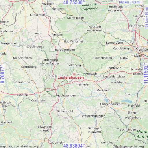
Leutershausen GPS coordinates[2]
49° 17' 55.284" North, 10° 24' 42.804" East
| Map corner | latitude | longitude |
|---|---|---|
| Upper-left | 49.75508°, | 9.70877° |
| Center: | 49.29869°, | 10.41189° |
| Lower-right: | 48.83804°, | 11.11502° |
| Map W x H: | 102×102 km | = 63.4×63.4mi |
| max Lat: | 55.01917° ⇑78.7% North |
| Leutershausen: | 49.29869° |
| min Lat: | ⇓21.3% South 47.40724° |
| min Long | Leutershausen | max Long |
| 5.92978° | 10.41189° | 14.98853° |
| W 57.3%⇐ | ⇒42.7% E |
Elevation
Elevation of Leutershausen is 430 m = 1411 ft, and this is 180.9 m = 594 ft above average elevation for this country.
| Max E: |
1256 m = 4121 ft | 20.5% |
| Leutershausen | 430 m 1411 ft | |
| Avg. | 249.1 m = 817 ft | |
Min E: |
-5 m = -16 ft | 79.5% |
See also: Germany elevation on elevation.city.
Geographical zone
Leutershausen is located in North temperate zone (between Tropic of Cancer and the Arctic Circle). Distance of this North polar circle is 1919.7 km =1192.8 mi to North.| Distance of | km | miles | from Leutershausen |
|---|---|---|---|
| North Pole | 4525.6 | 2812.1 | to North |
| Arctic Circle | 1919.7 | 1192.8 | to North |
| Tropic Cancer | 2875.6 | 1786.8 | to South |
| Equator | 5481.5 | 3406 | to South |


Nearby cities:
15 places around Leutershausen: (largest is in red/bold)
• Ansbach
13.2 km =8.2 mi,  87°
87°
• Aurach
5.4 km =3.4 mi,  176°
176°
• Buch am Wald
6.6 km =4.1 mi,  302°
302°
• Burgoberbach
14.4 km =8.9 mi,  120°
120°
• Colmberg
6.2 km =3.9 mi,  359°
359°
• Dombühl
10.5 km =6.5 mi,  241°
241°
• Flachslanden
13.3 km =8.3 mi,  33°
33°
• Geslau
10.3 km =6.4 mi,  317°
317°
• Herrieden
9.5 km =5.9 mi,  135°
135°
• Lehrberg
8.9 km =5.5 mi,  53°
53°
• Lichtenau
15.6 km =9.7 mi,  188°
188°
• Oberdachstetten
13.2 km =8.2 mi,  6°
6°
• Schillingsfürst
10.9 km =6.8 mi,  263°
263°
• Wieseth
15.6 km =9.7 mi,  160°
160°
• Windelsbach
13.9 km =8.6 mi, 324°
Sources, notices
• [Note1] Compared only with cities in Germany existing in our database
• [Src1] Map data: © OpenStreetMap contributors (CC-BY-SA)
• [Src2] Other city data from geonames.org with taken over terms of usage.
• [Src3] Geographical zone / Annual Mean Temperature by Robert A. Rohde @ Wikipedia
