Rothenburg ob der Tauber geodata
Rothenburg ob der Tauber (Bavaria) is a populated place; located in Germany in Europe/Berlin (GMT+2) time zone. With population of 11,106 people, there are 1488 cities with bigger population in this country. Compared to other cities in Germany, 77.5% of cities are located further ↑North; 53.2% of cities are located further ←West and 80.2% of cities have lower elevation than Rothenburg ob der Tauber. Note1
Administrative division(s):
- Level 1: Bavaria
- Level 2: Regierungsbezirk Mittelfranken
- Level 3: Landkreis Ansbach
- Level 4: Rothenburg ob der Tauber
Current local time in Rothenburg ob der Tauber:
01:13 PM, TuesdayDifference from your time zone: hours


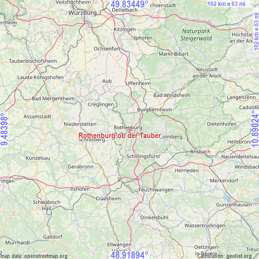
Rothenburg ob der Tauber GPS coordinates[2]
49° 22' 43.86" North, 10° 11' 13.596" East
| Map corner | latitude | longitude |
|---|---|---|
| Upper-left | 49.83449°, | 9.48398° |
| Center: | 49.37885°, | 10.18711° |
| Lower-right: | 48.91894°, | 10.89024° |
| Map W x H: | 101.8×101.8 km | = 63.3×63.3mi |
| max Lat: | 55.01917° ⇑77.5% North |
| Rothenburg ob der Tauber: | 49.37885° |
| min Lat: | ⇓22.5% South 47.40724° |
| min Long | Rothenburg ob d | max Long |
| 5.92978° | 10.18711° | 14.98853° |
| W 53.2%⇐ | ⇒46.8% E |
Elevation
Elevation of Rothenburg ob der Tauber is 434 m = 1424 ft, and this is 184.9 m = 607 ft above average elevation for this country.
| Max E: |
1256 m = 4121 ft | 19.8% |
| Rothenburg ob der Tauber | 434 m 1424 ft | |
| Avg. | 249.1 m = 817 ft | |
Min E: |
-5 m = -16 ft | 80.2% |
See also: Germany elevation on elevation.city.
Geographical zone
Rothenburg ob der Tauber is located in North temperate zone (between Tropic of Cancer and the Arctic Circle). Distance of this North polar circle is 1910.8 km =1187.3 mi to North.| Distance of | km | miles | from Rothenburg ob der Tauber |
|---|---|---|---|
| North Pole | 4516.6 | 2806.5 | to North |
| Arctic Circle | 1910.8 | 1187.3 | to North |
| Tropic Cancer | 2884.5 | 1792.3 | to South |
| Equator | 5490.4 | 3411.6 | to South |


Nearby cities:
15 places around Rothenburg ob der Tauber: (largest is in red/bold)
• Adelshofen
6.2 km =3.9 mi,  346°
346°
• Buch am Wald
12 km =7.5 mi,  116°
116°
• Burgbernheim
12.7 km =7.9 mi,  50°
50°
• Diebach
7.8 km =4.8 mi,  177°
177°
• Gallmersgarten
9.8 km =6.1 mi,  36°
36°
• Gebsattel
3.3 km =2.1 mi,  163°
163°
• Geslau
9.4 km =5.8 mi,  98°
98°
• Insingen
8.9 km =5.5 mi,  189°
189°
• Marktbergel
14.5 km =9 mi,  61°
61°
• Neusitz
2.9 km =1.8 mi,  105°
105°
• Ohrenbach
10.3 km =6.4 mi,  9°
9°
• Schillingsfürst
11.5 km =7.1 mi,  151°
151°
• Steinsfeld
4.7 km =2.9 mi,  26°
26°
• Wettringen
13.6 km =8.5 mi, 189°
• Windelsbach
8.5 km =5.3 mi,  73°
73°
Sources, notices
• [Note1] Compared only with cities in Germany existing in our database
• [Src1] Map data: © OpenStreetMap contributors (CC-BY-SA)
• [Src2] Other city data from geonames.org with taken over terms of usage.
• [Src3] Geographical zone / Annual Mean Temperature by Robert A. Rohde @ Wikipedia
