Windelsbach geodata
Windelsbach (Bavaria) is a seat of a fourth-order administrative division; located in Germany in Europe/Berlin (GMT+2) time zone. With population of 1,037 people, there are 7058 cities with bigger population in this country. Compared to other cities in Germany, 77.2% of cities are located further ↑North; 55.3% of cities are located further ←West and 82.8% of cities have lower elevation than Windelsbach. Note1
Administrative division(s):
- Level 1: Bavaria
- Level 2: Regierungsbezirk Mittelfranken
- Level 3: Landkreis Ansbach
- Level 4: Windelsbach


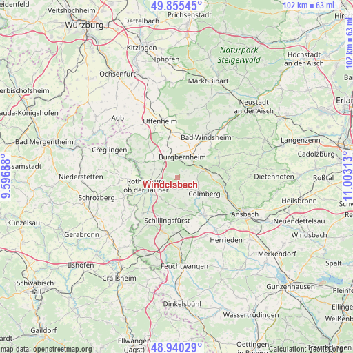
Windelsbach GPS coordinates[2]
49° 24' 0" North, 10° 18' 0" East
| Map corner | latitude | longitude |
|---|---|---|
| Upper-left | 49.85545°, | 9.59688° |
| Center: | 49.4°, | 10.3° |
| Lower-right: | 48.94029°, | 11.00313° |
| Map W x H: | 101.8×101.8 km | = 63.3×63.3mi |
| max Lat: | 55.01917° ⇑77.2% North |
| Windelsbach: | 49.4° |
| min Lat: | ⇓22.8% South 47.40724° |
| min Long | Windelsbach | max Long |
| 5.92978° | 10.3° | 14.98853° |
| W 55.3%⇐ | ⇒44.7% E |
Elevation
Elevation of Windelsbach is 452 m = 1483 ft, and this is 202.9 m = 666 ft above average elevation for this country.
| Max E: |
1256 m = 4121 ft | 17.2% |
| Windelsbach | 452 m 1483 ft | |
| Avg. | 249.1 m = 817 ft | |
Min E: |
-5 m = -16 ft | 82.8% |
See also: Germany elevation on elevation.city.
Geographical zone
Windelsbach is located in North temperate zone (between Tropic of Cancer and the Arctic Circle). Distance of this North polar circle is 1908.4 km =1185.8 mi to North.| Distance of | km | miles | from Windelsbach |
|---|---|---|---|
| North Pole | 4514.3 | 2805.1 | to North |
| Arctic Circle | 1908.4 | 1185.8 | to North |
| Tropic Cancer | 2886.8 | 1793.8 | to South |
| Equator | 5492.8 | 3413.1 | to South |


Nearby cities:
15 places around Windelsbach: (largest is in red/bold)
• Adelshofen
10.3 km =6.4 mi,  291°
291°
• Buch am Wald
8.2 km =5.1 mi,  161°
161°
• Burgbernheim
5.9 km =3.7 mi,  16°
16°
• Colmberg
9.5 km =5.9 mi,  121°
121°
• Gallmersgarten
6.1 km =3.8 mi,  336°
336°
• Gebsattel
9.1 km =5.7 mi,  232°
232°
• Geslau
3.9 km =2.4 mi, 163°
• Illesheim
10.7 km =6.6 mi,  33°
33°
• Marktbergel
6.5 km =4 mi,  44°
44°
• Neusitz
6.2 km =3.9 mi,  239°
239°
• Oberdachstetten
9.8 km =6.1 mi,  79°
79°
• Ohrenbach
10.2 km =6.3 mi,  320°
320°
• Rothenburg ob der Tauber
8.5 km =5.3 mi,  253°
253°
• Schillingsfürst
12.8 km =8 mi,  192°
192°
• Steinsfeld
6.3 km =3.9 mi, 287°
Sources, notices
• [Note1] Compared only with cities in Germany existing in our database
• [Src1] Map data: © OpenStreetMap contributors (CC-BY-SA)
• [Src2] Other city data from geonames.org with taken over terms of usage.
• [Src3] Geographical zone / Annual Mean Temperature by Robert A. Rohde @ Wikipedia
