Aurach geodata
Aurach (Bavaria) is a seat of a fourth-order administrative division; located in Germany in Europe/Berlin (GMT+2) time zone. In our database, there are 11009 cities with bigger population. Compared to other cities in Germany, 79.5% of cities are located further ↑North; 57.3% of cities are located further ←West and 80.7% of cities have lower elevation than Aurach. Note1
Administrative division(s):
- Level 1: Bavaria
- Level 2: Regierungsbezirk Mittelfranken
- Level 3: Landkreis Ansbach
- Level 4: Aurach


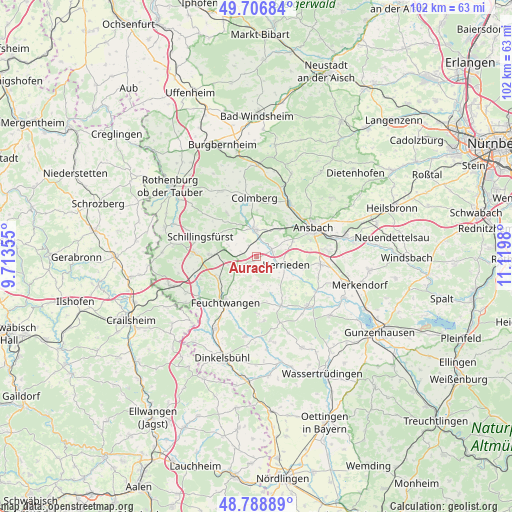
Aurach GPS coordinates[2]
49° 15' 0" North, 10° 25' 0.012" East
| Map corner | latitude | longitude |
|---|---|---|
| Upper-left | 49.70684°, | 9.71355° |
| Center: | 49.25°, | 10.41667° |
| Lower-right: | 48.78889°, | 11.1198° |
| Map W x H: | 102.1×102.1 km | = 63.4×63.4mi |
| max Lat: | 55.01917° ⇑79.5% North |
| Aurach: | 49.25° |
| min Lat: | ⇓20.5% South 47.40724° |
| min Long | Aurach | max Long |
| 5.92978° | 10.41667° | 14.98853° |
| W 57.3%⇐ | ⇒42.7% E |
Elevation
Elevation of Aurach is 437 m = 1434 ft, and this is 187.9 m = 616 ft above average elevation for this country.
| Max E: |
1256 m = 4121 ft | 19.3% |
| Aurach | 437 m 1434 ft | |
| Avg. | 249.1 m = 817 ft | |
Min E: |
-5 m = -16 ft | 80.7% |
See also: Germany elevation on elevation.city.
Geographical zone
Aurach is located in North temperate zone (between Tropic of Cancer and the Arctic Circle). Distance of this North polar circle is 1925.1 km =1196.2 mi to North.| Distance of | km | miles | from Aurach |
|---|---|---|---|
| North Pole | 4531 | 2815.4 | to North |
| Arctic Circle | 1925.1 | 1196.2 | to North |
| Tropic Cancer | 2870.2 | 1783.5 | to South |
| Equator | 5476.1 | 3402.7 | to South |


Nearby cities:
15 places around Aurach: (largest is in red/bold)
• Ansbach
14.2 km =8.8 mi,  64°
64°
• Buch am Wald
10.7 km =6.6 mi,  326°
326°
• Burgoberbach
12.2 km =7.6 mi,  98°
98°
• Burk
13.8 km =8.6 mi,  160°
160°
• Colmberg
11.7 km =7.3 mi,  358°
358°
• Dentlein am Forst
11.4 km =7.1 mi,  177°
177°
• Dombühl
9.5 km =5.9 mi,  272°
272°
• Feuchtwangen
11.2 km =7 mi,  210°
210°
• Geslau
14.9 km =9.3 mi, 330°
• Herrieden
6.4 km =4 mi, 102°
• Lehrberg
12.6 km =7.8 mi,  32°
32°
• Leutershausen
5.4 km =3.4 mi, 356°
• Lichtenau
10.4 km =6.5 mi,  195°
195°
• Schillingsfürst
11.9 km =7.4 mi,  290°
290°
• Wieseth
10.5 km =6.5 mi,  152°
152°
Sources, notices
• [Note1] Compared only with cities in Germany existing in our database
• [Src1] Map data: © OpenStreetMap contributors (CC-BY-SA)
• [Src2] Other city data from geonames.org with taken over terms of usage.
• [Src3] Geographical zone / Annual Mean Temperature by Robert A. Rohde @ Wikipedia
