Scheibenhardt geodata
Scheibenhardt (Rheinland-Pfalz) is a seat of a fourth-order administrative division; located in Germany in Europe/Berlin (GMT+2) time zone. With population of 731 people, there are 8187 cities with bigger population in this country. Compared to other cities in Germany, 83.2% of cities are located further ↑North; 74.8% of cities are located further →East and 64.2% of cities have higher elevation than Scheibenhardt. Note1
Administrative division(s):
- Level 1: Rheinland-Pfalz
- Level 3: Landkreis Germersheim
- Level 4: Scheibenhardt


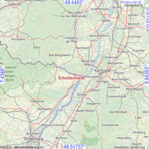
Scheibenhardt GPS coordinates[2]
48° 58' 52.212" North, 8° 8' 23.748" East
| Map corner | latitude | longitude |
|---|---|---|
| Upper-left | 49.4405°, | 7.4368° |
| Center: | 48.98117°, | 8.13993° |
| Lower-right: | 48.51757°, | 8.84305° |
| Map W x H: | 102.6×102.6 km | = 63.8×63.8mi |
| max Lat: | 55.01917° ⇑83.2% North |
| Scheibenhardt: | 48.98117° |
| min Lat: | ⇓16.8% South 47.40724° |
| min Long | Scheibenhardt | max Long |
| 5.92978° | 8.13993° | 14.98853° |
| W 25.2%⇐ | ⇒74.8% E |
Elevation
Elevation of Scheibenhardt is 125 m = 410 ft, and this is 124.1 m = 407 ft below average elevation for this country.
| Max E: |
1256 m = 4121 ft | 64.2% |
| Avg. | 249.1 m = 817 ft | |
| Scheibenhardt | 125 m = 410 ft | |
Min E: |
-5 m = -16 ft | 35.8% |
See also: Germany elevation on elevation.city.
Geographical zone
Scheibenhardt is located in North temperate zone (between Tropic of Cancer and the Arctic Circle). Distance of this North polar circle is 1955 km =1214.8 mi to North.| Distance of | km | miles | from Scheibenhardt |
|---|---|---|---|
| North Pole | 4560.9 | 2834 | to North |
| Arctic Circle | 1955 | 1214.8 | to North |
| Tropic Cancer | 2840.3 | 1764.9 | to South |
| Equator | 5446.2 | 3384.1 | to South |


Nearby cities:
15 places around Scheibenhardt: (largest is in red/bold)
• Au am Rhein
7.6 km =4.7 mi,  116°
116°
• Berg
4.6 km =2.9 mi,  86°
86°
• Bietigheim
11.4 km =7.1 mi,  134°
134°
• Durmersheim
10.7 km =6.6 mi, 119°
• Freckenfeld
9.5 km =5.9 mi,  348°
348°
• Hagenbach
9 km =5.6 mi,  63°
63°
• Kandel
12 km =7.5 mi,  20°
20°
• Kapsweyer
11.1 km =6.9 mi,  308°
308°
• Minfeld
10.1 km =6.3 mi,  2°
2°
• Neuburg
7.9 km =4.9 mi,  83°
83°
• Niederotterbach
11.2 km =7 mi,  321°
321°
• Steinfeld
10.6 km =6.6 mi, 314°
• Steinmauern
9.8 km =6.1 mi,  154°
154°
• Vollmersweiler
10.4 km =6.5 mi,  333°
333°
• Wörth am Rhein
11.5 km =7.1 mi,  49°
49°
Sources, notices
• [Note1] Compared only with cities in Germany existing in our database
• [Src1] Map data: © OpenStreetMap contributors (CC-BY-SA)
• [Src2] Other city data from geonames.org with taken over terms of usage.
• [Src3] Geographical zone / Annual Mean Temperature by Robert A. Rohde @ Wikipedia
