Wörth am Rhein geodata
Wörth am Rhein (Rheinland-Pfalz) is a populated place; located in Germany in Europe/Berlin (GMT+2) time zone. With population of 17,272 people, there are 924 cities with bigger population in this country. Compared to other cities in Germany, 82.4% of cities are located further ↑North; 73.3% of cities are located further →East and 65.7% of cities have higher elevation than Wörth am Rhein. Note1
Administrative division(s):
- Level 1: Rheinland-Pfalz
- Level 3: Landkreis Germersheim
- Level 4: Wörth am Rhein


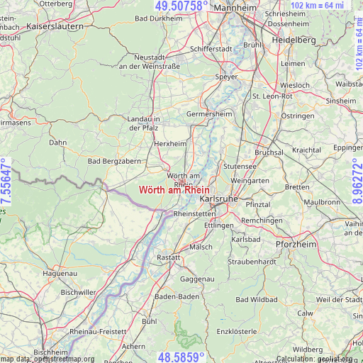
Wörth am Rhein GPS coordinates[2]
49° 2' 55.968" North, 8° 15' 34.524" East
| Map corner | latitude | longitude |
|---|---|---|
| Upper-left | 49.50758°, | 7.55647° |
| Center: | 49.04888°, | 8.25959° |
| Lower-right: | 48.5859°, | 8.96272° |
| Map W x H: | 102.5×102.5 km | = 63.7×63.7mi |
| max Lat: | 55.01917° ⇑82.4% North |
| Wörth am Rhein: | 49.04888° |
| min Lat: | ⇓17.6% South 47.40724° |
| min Long | Wörth am Rhein | max Long |
| 5.92978° | 8.25959° | 14.98853° |
| W 26.7%⇐ | ⇒73.3% E |
Elevation
Elevation of Wörth am Rhein is 116 m = 381 ft, and this is 133.1 m = 437 ft below average elevation for this country.
| Max E: |
1256 m = 4121 ft | 65.7% |
| Avg. | 249.1 m = 817 ft | |
| Wörth am Rhein | 116 m = 381 ft | |
Min E: |
-5 m = -16 ft | 34.3% |
See also: Germany elevation on elevation.city.
Geographical zone
Wörth am Rhein is located in North temperate zone (between Tropic of Cancer and the Arctic Circle). Distance of this North polar circle is 1947.4 km =1210.1 mi to North.| Distance of | km | miles | from Wörth am Rhein |
|---|---|---|---|
| North Pole | 4553.3 | 2829.3 | to North |
| Arctic Circle | 1947.4 | 1210.1 | to North |
| Tropic Cancer | 2847.8 | 1769.5 | to South |
| Equator | 5453.7 | 3388.8 | to South |


Nearby cities:
15 places around Wörth am Rhein: (largest is in red/bold)
• Au am Rhein
11.2 km =7 mi,  189°
189°
• Berg
8.3 km =5.2 mi,  210°
210°
• Eggenstein-Leopoldshafen
11.1 km =6.9 mi,  65°
65°
• Erlenbach
8.7 km =5.4 mi,  322°
322°
• Freckenfeld
10.8 km =6.7 mi,  279°
279°
• Hagenbach
3.6 km =2.2 mi, 190°
• Hatzenbühl
7 km =4.3 mi,  351°
351°
• Jockgrim
5 km =3.1 mi,  12°
12°
• Kandel
5.9 km =3.7 mi,  309°
309°
• Leimersheim
10.4 km =6.5 mi,  36°
36°
• Minfeld
8.7 km =5.4 mi,  286°
286°
• Neuburg
6.7 km =4.2 mi, 187°
• Neupotz
8.8 km =5.5 mi,  29°
29°
• Rheinstetten
9.6 km =6 mi,  158°
158°
• Rheinzabern
7.8 km =4.8 mi, 9°
Sources, notices
• [Note1] Compared only with cities in Germany existing in our database
• [Src1] Map data: © OpenStreetMap contributors (CC-BY-SA)
• [Src2] Other city data from geonames.org with taken over terms of usage.
• [Src3] Geographical zone / Annual Mean Temperature by Robert A. Rohde @ Wikipedia
