Hagenbach geodata
Hagenbach (Rheinland-Pfalz) is a seat of a fourth-order administrative division; located in Germany in Europe/Berlin (GMT+2) time zone. With population of 5,495 people, there are 2628 cities with bigger population in this country. Compared to other cities in Germany, 82.8% of cities are located further ↑North; 73.5% of cities are located further →East and 67% of cities have higher elevation than Hagenbach. Note1
Administrative division(s):
- Level 1: Rheinland-Pfalz
- Level 3: Landkreis Germersheim
- Level 4: Hagenbach


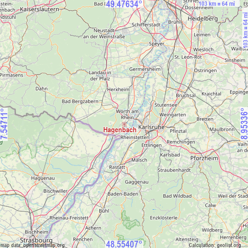
Hagenbach GPS coordinates[2]
49° 1' 2.424" North, 8° 15' 0.864" East
| Map corner | latitude | longitude |
|---|---|---|
| Upper-left | 49.47634°, | 7.54711° |
| Center: | 49.01734°, | 8.25024° |
| Lower-right: | 48.55407°, | 8.95336° |
| Map W x H: | 102.5×102.5 km | = 63.7×63.7mi |
| max Lat: | 55.01917° ⇑82.8% North |
| Hagenbach: | 49.01734° |
| min Lat: | ⇓17.2% South 47.40724° |
| min Long | Hagenbach | max Long |
| 5.92978° | 8.25024° | 14.98853° |
| W 26.5%⇐ | ⇒73.5% E |
Elevation
Elevation of Hagenbach is 108 m = 354 ft, and this is 141.1 m = 463 ft below average elevation for this country.
| Max E: |
1256 m = 4121 ft | 67% |
| Avg. | 249.1 m = 817 ft | |
| Hagenbach | 108 m = 354 ft | |
Min E: |
-5 m = -16 ft | 33% |
See also: Germany elevation on elevation.city.
Geographical zone
Hagenbach is located in North temperate zone (between Tropic of Cancer and the Arctic Circle). Distance of this North polar circle is 1951 km =1212.3 mi to North.| Distance of | km | miles | from Hagenbach |
|---|---|---|---|
| North Pole | 4556.8 | 2831.5 | to North |
| Arctic Circle | 1951 | 1212.3 | to North |
| Tropic Cancer | 2844.3 | 1767.4 | to South |
| Equator | 5450.2 | 3386.6 | to South |


Nearby cities:
15 places around Hagenbach: (largest is in red/bold)
• Au am Rhein
7.6 km =4.7 mi,  189°
189°
• Berg
5.1 km =3.2 mi,  223°
223°
• Durmersheim
9.4 km =5.8 mi,  172°
172°
• Erlenbach
11.4 km =7.1 mi,  336°
336°
• Freckenfeld
11.3 km =7 mi,  298°
298°
• Hatzenbühl
10.4 km =6.5 mi,  358°
358°
• Jockgrim
8.6 km =5.3 mi,  11°
11°
• Kandel
8.2 km =5.1 mi,  332°
332°
• Karlsruhe
11.3 km =7 mi,  94°
94°
• Minfeld
9.7 km =6 mi,  308°
308°
• Neuburg
3.1 km =1.9 mi,  184°
184°
• Rheinstetten
6.8 km =4.2 mi,  142°
142°
• Rheinzabern
11.4 km =7.1 mi, 10°
• Scheibenhardt
9 km =5.6 mi,  243°
243°
• Wörth am Rhein
3.6 km =2.2 mi, 10°
Sources, notices
• [Note1] Compared only with cities in Germany existing in our database
• [Src1] Map data: © OpenStreetMap contributors (CC-BY-SA)
• [Src2] Other city data from geonames.org with taken over terms of usage.
• [Src3] Geographical zone / Annual Mean Temperature by Robert A. Rohde @ Wikipedia
