Radevormwald geodata
Radevormwald (North Rhine-Westphalia) is a populated place; located in Germany in Europe/Berlin (GMT+2) time zone. With population of 24,100 people, there are 622 cities with bigger population in this country. Compared to other cities in Germany, 61.6% of cities are located further ↓South; 89.1% of cities are located further →East and 71.8% of cities have lower elevation than Radevormwald. Note1
Administrative division(s):
- Level 1: North Rhine-Westphalia
- Level 2: Regierungsbezirk Köln
- Level 3: Oberbergischer Kreis
- Level 4: Radevormwald


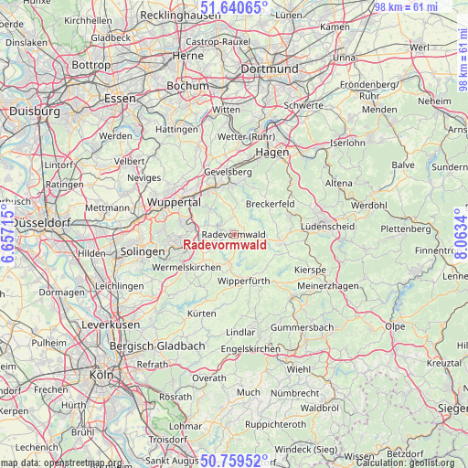
Radevormwald GPS coordinates[2]
51° 12' 7.884" North, 7° 21' 36.972" East
| Map corner | latitude | longitude |
|---|---|---|
| Upper-left | 51.64065°, | 6.65715° |
| Center: | 51.20219°, | 7.36027° |
| Lower-right: | 50.75952°, | 8.0634° |
| Map W x H: | 98×98 km | = 60.9×60.9mi |
| max Lat: | 55.01917° ⇑38.4% North |
| Radevormwald: | 51.20219° |
| min Lat: | ⇓61.6% South 47.40724° |
| min Long | Radevormwald | max Long |
| 5.92978° | 7.36027° | 14.98853° |
| W 10.9%⇐ | ⇒89.1% E |
Elevation
Elevation of Radevormwald is 373 m = 1224 ft, and this is 123.9 m = 406 ft above average elevation for this country.
| Max E: |
1256 m = 4121 ft | 28.2% |
| Radevormwald | 373 m 1224 ft | |
| Avg. | 249.1 m = 817 ft | |
Min E: |
-5 m = -16 ft | 71.8% |
See also: Germany elevation on elevation.city.
Geographical zone
Radevormwald is located in North temperate zone (between Tropic of Cancer and the Arctic Circle). Distance of this North polar circle is 1708 km =1061.3 mi to North.| Distance of | km | miles | from Radevormwald |
|---|---|---|---|
| North Pole | 4313.9 | 2680.5 | to North |
| Arctic Circle | 1708 | 1061.3 | to North |
| Tropic Cancer | 3087.2 | 1918.3 | to South |
| Equator | 5693.1 | 3537.5 | to South |


Nearby cities:
15 places around Radevormwald: (largest is in red/bold)
• Breckerfeld
9.8 km =6.1 mi,  49°
49°
• Ennepetal
10.7 km =6.6 mi,  0°
0°
• Gevelsberg
13.1 km =8.1 mi,  353°
353°
• Halver
9.8 km =6.1 mi,  100°
100°
• Hückeswagen
5.9 km =3.7 mi,  190°
190°
• Kierspe
17.8 km =11.1 mi,  115°
115°
• Kürten
18.1 km =11.2 mi,  201°
201°
• Marienheide
17.8 km =11.1 mi,  138°
138°
• Remscheid
12 km =7.5 mi,  257°
257°
• Schalksmühle
12.5 km =7.8 mi,  69°
69°
• Schwelm
10.4 km =6.5 mi,  333°
333°
• Sprockhövel
18 km =11.2 mi, 333°
• Wermelskirchen
12.2 km =7.6 mi,  235°
235°
• Wipperfürth
9.9 km =6.2 mi,  164°
164°
• Wuppertal
15.9 km =9.9 mi,  292°
292°
Sources, notices
• [Note1] Compared only with cities in Germany existing in our database
• [Src1] Map data: © OpenStreetMap contributors (CC-BY-SA)
• [Src2] Other city data from geonames.org with taken over terms of usage.
• [Src3] Geographical zone / Annual Mean Temperature by Robert A. Rohde @ Wikipedia
