Halver geodata
Halver (North Rhine-Westphalia) is a populated place; located in Germany in Europe/Berlin (GMT+2) time zone. With population of 17,650 people, there are 901 cities with bigger population in this country. Compared to other cities in Germany, 61.3% of cities are located further ↓South; 87.1% of cities are located further →East and 77.2% of cities have lower elevation than Halver. Note1
Administrative division(s):
- Level 1: North Rhine-Westphalia
- Level 2: Regierungsbezirk Arnsberg
- Level 3: Märkischer Kreis
- Level 4: Halver


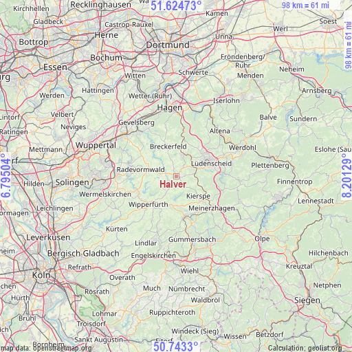
Halver GPS coordinates[2]
51° 11' 10.032" North, 7° 29' 53.412" East
| Map corner | latitude | longitude |
|---|---|---|
| Upper-left | 51.62473°, | 6.79504° |
| Center: | 51.18612°, | 7.49817° |
| Lower-right: | 50.7433°, | 8.20129° |
| Map W x H: | 98×98 km | = 60.9×60.9mi |
| max Lat: | 55.01917° ⇑38.7% North |
| Halver: | 51.18612° |
| min Lat: | ⇓61.3% South 47.40724° |
| min Long | Halver | max Long |
| 5.92978° | 7.49817° | 14.98853° |
| W 12.9%⇐ | ⇒87.1% E |
Elevation
Elevation of Halver is 414 m = 1358 ft, and this is 164.9 m = 541 ft above average elevation for this country.
| Max E: |
1256 m = 4121 ft | 22.8% |
| Halver | 414 m 1358 ft | |
| Avg. | 249.1 m = 817 ft | |
Min E: |
-5 m = -16 ft | 77.2% |
See also: Germany elevation on elevation.city.
Geographical zone
Halver is located in North temperate zone (between Tropic of Cancer and the Arctic Circle). Distance of this North polar circle is 1709.8 km =1062.4 mi to North.| Distance of | km | miles | from Halver |
|---|---|---|---|
| North Pole | 4315.7 | 2681.7 | to North |
| Arctic Circle | 1709.8 | 1062.4 | to North |
| Tropic Cancer | 3085.4 | 1917.2 | to South |
| Equator | 5691.4 | 3536.5 | to South |


Nearby cities:
15 places around Halver: (largest is in red/bold)
• Altena
17.2 km =10.7 mi,  45°
45°
• Breckerfeld
8.4 km =5.2 mi,  345°
345°
• Ennepetal
15.6 km =9.7 mi,  322°
322°
• Gummersbach
18.4 km =11.4 mi,  165°
165°
• Herscheid
17.1 km =10.6 mi,  92°
92°
• Hückeswagen
11.4 km =7.1 mi,  249°
249°
• Kierspe
8.7 km =5.4 mi,  131°
131°
• Lüdenscheid
9.7 km =6 mi,  67°
67°
• Marienheide
11.7 km =7.3 mi, 168°
• Meinerzhagen
13.7 km =8.5 mi, 129°
• Nachrodt-Wiblingwerde
16.7 km =10.4 mi,  29°
29°
• Radevormwald
9.8 km =6.1 mi,  280°
280°
• Schalksmühle
6.5 km =4 mi,  18°
18°
• Schwelm
18.1 km =11.2 mi,  308°
308°
• Wipperfürth
10.4 km =6.5 mi,  221°
221°
Sources, notices
• [Note1] Compared only with cities in Germany existing in our database
• [Src1] Map data: © OpenStreetMap contributors (CC-BY-SA)
• [Src2] Other city data from geonames.org with taken over terms of usage.
• [Src3] Geographical zone / Annual Mean Temperature by Robert A. Rohde @ Wikipedia
