Lüdenscheid geodata
Lüdenscheid (North Rhine-Westphalia) is a seat of a third-order administrative division; located in Germany in Europe/Berlin (GMT+2) time zone. With population of 79,386 people, there are 125 cities with bigger population in this country. Compared to other cities in Germany, 61.8% of cities are located further ↓South; 84.4% of cities are located further →East and 76.7% of cities have lower elevation than Lüdenscheid. Note1
Administrative division(s):
- Level 1: North Rhine-Westphalia
- Level 2: Regierungsbezirk Arnsberg
- Level 3: Märkischer Kreis
- Level 4: Lüdenscheid


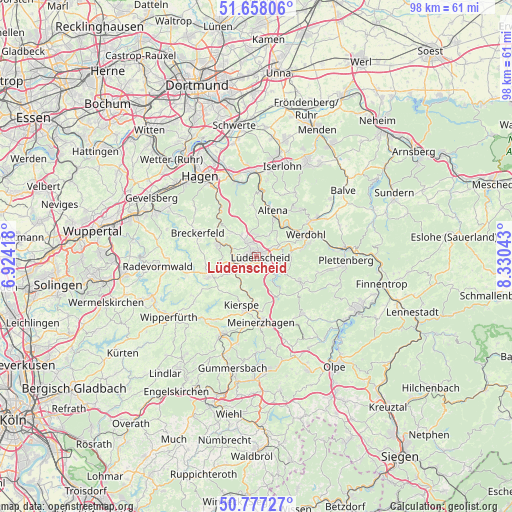
Lüdenscheid GPS coordinates[2]
51° 13' 11.172" North, 7° 37' 38.28" East
| Map corner | latitude | longitude |
|---|---|---|
| Upper-left | 51.65806°, | 6.92418° |
| Center: | 51.21977°, | 7.6273° |
| Lower-right: | 50.77727°, | 8.33043° |
| Map W x H: | 97.9×97.9 km | = 60.8×60.8mi |
| max Lat: | 55.01917° ⇑38.2% North |
| Lüdenscheid: | 51.21977° |
| min Lat: | ⇓61.8% South 47.40724° |
| min Long | Lüdenscheid | max Long |
| 5.92978° | 7.6273° | 14.98853° |
| W 15.6%⇐ | ⇒84.4% E |
Elevation
Elevation of Lüdenscheid is 410 m = 1345 ft, and this is 160.9 m = 528 ft above average elevation for this country.
| Max E: |
1256 m = 4121 ft | 23.3% |
| Lüdenscheid | 410 m 1345 ft | |
| Avg. | 249.1 m = 817 ft | |
Min E: |
-5 m = -16 ft | 76.7% |
See also: Lüdenscheid elevation on elevation.city.
Geographical zone
Lüdenscheid is located in North temperate zone (between Tropic of Cancer and the Arctic Circle). Distance of this North polar circle is 1706.1 km =1060.1 mi to North.| Distance of | km | miles | from Lüdenscheid |
|---|---|---|---|
| North Pole | 4312 | 2679.4 | to North |
| Arctic Circle | 1706.1 | 1060.1 | to North |
| Tropic Cancer | 3089.2 | 1919.5 | to South |
| Equator | 5695.1 | 3538.8 | to South |


Nearby cities:
15 places around Lüdenscheid: (largest is in red/bold)
• Altena
8.9 km =5.5 mi,  21°
21°
• Breckerfeld
11.9 km =7.4 mi,  291°
291°
• Hagen
19.1 km =11.9 mi,  325°
325°
• Halver
9.7 km =6 mi,  247°
247°
• Herscheid
9.3 km =5.8 mi,  119°
119°
• Iserlohn
18.1 km =11.2 mi, 16°
• Kierspe
9.9 km =6.2 mi,  194°
194°
• Marienheide
16.6 km =10.3 mi,  203°
203°
• Meinerzhagen
12.6 km =7.8 mi,  173°
173°
• Nachrodt-Wiblingwerde
10.8 km =6.7 mi,  356°
356°
• Neuenrade
12.9 km =8 mi,  57°
57°
• Plettenberg
17.1 km =10.6 mi,  93°
93°
• Radevormwald
18.7 km =11.6 mi,  264°
264°
• Schalksmühle
7.3 km =4.5 mi, 288°
• Werdohl
10.7 km =6.6 mi,  65°
65°
Sources, notices
• [Note1] Compared only with cities in Germany existing in our database
• [Src1] Map data: © OpenStreetMap contributors (CC-BY-SA)
• [Src2] Other city data from geonames.org with taken over terms of usage.
• [Src3] Geographical zone / Annual Mean Temperature by Robert A. Rohde @ Wikipedia
