Herscheid geodata
Herscheid (North Rhine-Westphalia) is a seat of a fourth-order administrative division; located in Germany in Europe/Berlin (GMT+2) time zone. With population of 7,658 people, there are 2024 cities with bigger population in this country. Compared to other cities in Germany, 61.2% of cities are located further ↓South; 82.2% of cities are located further →East and 79.1% of cities have lower elevation than Herscheid. Note1
Administrative division(s):
- Level 1: North Rhine-Westphalia
- Level 2: Regierungsbezirk Arnsberg
- Level 3: Märkischer Kreis
- Level 4: Herscheid


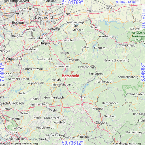
Herscheid GPS coordinates[2]
51° 10' 44.436" North, 7° 44' 36.78" East
| Map corner | latitude | longitude |
|---|---|---|
| Upper-left | 51.61769°, | 7.04043° |
| Center: | 51.17901°, | 7.74355° |
| Lower-right: | 50.73612°, | 8.44668° |
| Map W x H: | 98×98 km | = 60.9×60.9mi |
| max Lat: | 55.01917° ⇑38.8% North |
| Herscheid: | 51.17901° |
| min Lat: | ⇓61.2% South 47.40724° |
| min Long | Herscheid | max Long |
| 5.92978° | 7.74355° | 14.98853° |
| W 17.8%⇐ | ⇒82.2% E |
Elevation
Elevation of Herscheid is 428 m = 1404 ft, and this is 178.9 m = 587 ft above average elevation for this country.
| Max E: |
1256 m = 4121 ft | 20.9% |
| Herscheid | 428 m 1404 ft | |
| Avg. | 249.1 m = 817 ft | |
Min E: |
-5 m = -16 ft | 79.1% |
See also: Germany elevation on elevation.city.
Geographical zone
Herscheid is located in North temperate zone (between Tropic of Cancer and the Arctic Circle). Distance of this North polar circle is 1710.6 km =1062.9 mi to North.| Distance of | km | miles | from Herscheid |
|---|---|---|---|
| North Pole | 4316.5 | 2682.1 | to North |
| Arctic Circle | 1710.6 | 1062.9 | to North |
| Tropic Cancer | 3084.7 | 1916.7 | to South |
| Equator | 5690.6 | 3536 | to South |


Nearby cities:
15 places around Herscheid: (largest is in red/bold)
• Altena
13.8 km =8.6 mi,  339°
339°
• Attendorn
12.6 km =7.8 mi,  117°
117°
• Bamenohl
16.8 km =10.4 mi,  95°
95°
• Bergneustadt
18.2 km =11.3 mi,  199°
199°
• Drolshagen
17.4 km =10.8 mi,  173°
173°
• Finnentrop
16 km =9.9 mi,  94°
94°
• Halver
17.1 km =10.6 mi,  272°
272°
• Kierspe
11.8 km =7.3 mi,  244°
244°
• Lüdenscheid
9.3 km =5.8 mi,  299°
299°
• Meinerzhagen
10.4 km =6.5 mi,  219°
219°
• Nachrodt-Wiblingwerde
17.7 km =11 mi,  330°
330°
• Neuenrade
11.9 km =7.4 mi,  13°
13°
• Plettenberg
9.6 km =6 mi,  69°
69°
• Schalksmühle
16.5 km =10.3 mi,  294°
294°
• Werdohl
9.2 km =5.7 mi, 9°
Sources, notices
• [Note1] Compared only with cities in Germany existing in our database
• [Src1] Map data: © OpenStreetMap contributors (CC-BY-SA)
• [Src2] Other city data from geonames.org with taken over terms of usage.
• [Src3] Geographical zone / Annual Mean Temperature by Robert A. Rohde @ Wikipedia
