Werdohl geodata
Werdohl (North Rhine-Westphalia) is a populated place; located in Germany in Europe/Berlin (GMT+2) time zone. With population of 20,366 people, there are 758 cities with bigger population in this country. Compared to other cities in Germany, 62.6% of cities are located further ↓South; 81.8% of cities are located further →East and 53.4% of cities have higher elevation than Werdohl. Note1
Administrative division(s):
- Level 1: North Rhine-Westphalia
- Level 2: Regierungsbezirk Arnsberg
- Level 3: Märkischer Kreis
- Level 4: Werdohl


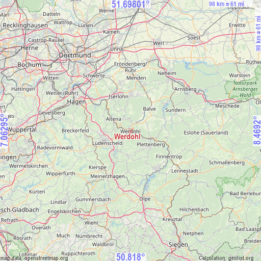
Werdohl GPS coordinates[2]
51° 15' 36.396" North, 7° 45' 57.888" East
| Map corner | latitude | longitude |
|---|---|---|
| Upper-left | 51.69801°, | 7.06295° |
| Center: | 51.26011°, | 7.76608° |
| Lower-right: | 50.818°, | 8.4692° |
| Map W x H: | 97.8×97.8 km | = 60.8×60.8mi |
| max Lat: | 55.01917° ⇑37.4% North |
| Werdohl: | 51.26011° |
| min Lat: | ⇓62.6% South 47.40724° |
| min Long | Werdohl | max Long |
| 5.92978° | 7.76608° | 14.98853° |
| W 18.2%⇐ | ⇒81.8% E |
Elevation
Elevation of Werdohl is 201 m = 659 ft, and this is 48.1 m = 158 ft below average elevation for this country.
| Max E: |
1256 m = 4121 ft | 53.4% |
| Avg. | 249.1 m = 817 ft | |
| Werdohl | 201 m = 659 ft | |
Min E: |
-5 m = -16 ft | 46.6% |
See also: Germany elevation on elevation.city.
Geographical zone
Werdohl is located in North temperate zone (between Tropic of Cancer and the Arctic Circle). Distance of this North polar circle is 1701.6 km =1057.3 mi to North.| Distance of | km | miles | from Werdohl |
|---|---|---|---|
| North Pole | 4307.5 | 2676.6 | to North |
| Arctic Circle | 1701.6 | 1057.3 | to North |
| Tropic Cancer | 3093.7 | 1922.3 | to South |
| Equator | 5699.6 | 3541.6 | to South |


Nearby cities:
15 places around Werdohl: (largest is in red/bold)
• Altena
7.5 km =4.7 mi,  300°
300°
• Attendorn
17.7 km =11 mi,  147°
147°
• Balve
10.5 km =6.5 mi,  40°
40°
• Bamenohl
18.5 km =11.5 mi,  124°
124°
• Finnentrop
17.7 km =11 mi,  125°
125°
• Hemer
14.1 km =8.8 mi,  1°
1°
• Herscheid
9.2 km =5.7 mi,  189°
189°
• Iserlohn
13.6 km =8.5 mi,  341°
341°
• Kierspe
18.6 km =11.6 mi,  221°
221°
• Lüdenscheid
10.7 km =6.6 mi,  245°
245°
• Nachrodt-Wiblingwerde
12.1 km =7.5 mi, 301°
• Neuenrade
2.8 km =1.7 mi,  24°
24°
• Plettenberg
9.3 km =5.8 mi, 127°
• Schalksmühle
16.7 km =10.4 mi,  262°
262°
• Sundern
18.2 km =11.3 mi,  65°
65°
Sources, notices
• [Note1] Compared only with cities in Germany existing in our database
• [Src1] Map data: © OpenStreetMap contributors (CC-BY-SA)
• [Src2] Other city data from geonames.org with taken over terms of usage.
• [Src3] Geographical zone / Annual Mean Temperature by Robert A. Rohde @ Wikipedia
