Sandersdorf geodata
Sandersdorf (Saxony-Anhalt) is a populated place; located in Germany in Europe/Berlin (GMT+2) time zone. With population of 6,580 people, there are 2285 cities with bigger population in this country. Compared to other cities in Germany, 68% of cities are located further ↓South; 85.4% of cities are located further ←West and 70.7% of cities have higher elevation than Sandersdorf. Note1
Administrative division(s):
- Level 1: Saxony-Anhalt
- Level 3: Anhalt-Bitterfeld
- Level 4: Sandersdorf-Brehna


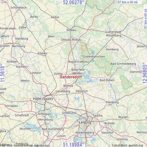
Sandersdorf GPS coordinates[2]
51° 37' 42.276" North, 12° 15' 53.712" East
| Map corner | latitude | longitude |
|---|---|---|
| Upper-left | 52.06278°, | 11.5618° |
| Center: | 51.62841°, | 12.26492° |
| Lower-right: | 51.18984°, | 12.96805° |
| Map W x H: | 97.1×97.1 km | = 60.3×60.3mi |
| max Lat: | 55.01917° ⇑32% North |
| Sandersdorf: | 51.62841° |
| min Lat: | ⇓68% South 47.40724° |
| min Long | Sandersdorf | max Long |
| 5.92978° | 12.26492° | 14.98853° |
| W 85.4%⇐ | ⇒14.6% E |
Elevation
Elevation of Sandersdorf is 87 m = 285 ft, and this is 162.1 m = 532 ft below average elevation for this country.
| Max E: |
1256 m = 4121 ft | 70.7% |
| Avg. | 249.1 m = 817 ft | |
| Sandersdorf | 87 m = 285 ft | |
Min E: |
-5 m = -16 ft | 29.3% |
See also: Germany elevation on elevation.city.
Geographical zone
Sandersdorf is located in North temperate zone (between Tropic of Cancer and the Arctic Circle). Distance of this North polar circle is 1660.6 km =1031.8 mi to North.| Distance of | km | miles | from Sandersdorf |
|---|---|---|---|
| North Pole | 4266.5 | 2651.1 | to North |
| Arctic Circle | 1660.6 | 1031.8 | to North |
| Tropic Cancer | 3134.6 | 1947.7 | to South |
| Equator | 5740.5 | 3567 | to South |


Nearby cities:
15 places around Sandersdorf: (largest is in red/bold)
• Bitterfeld-Wolfen
4.1 km =2.5 mi,  97°
97°
• Bobbau
6.6 km =4.1 mi,  4°
4°
• Friedersdorf
7.3 km =4.5 mi,  72°
72°
• Glebitzsch
6.2 km =3.9 mi,  234°
234°
• Greppin
3.2 km =2 mi,  50°
50°
• Großzöberitz
6 km =3.7 mi,  260°
260°
• Holzweißig
4.5 km =2.8 mi,  138°
138°
• Jeßnitz
6.5 km =4 mi,  21°
21°
• Petersroda
6.7 km =4.2 mi,  165°
165°
• Ramsin
2.7 km =1.7 mi,  223°
223°
• Renneritz
4 km =2.5 mi, 222°
• Roitzsch
5.9 km =3.7 mi,  181°
181°
• Thalheim
3.7 km =2.3 mi,  316°
316°
• Wolfen
3.7 km =2.3 mi, 4°
• Zscherndorf
2 km =1.2 mi, 174°
Sources, notices
• [Note1] Compared only with cities in Germany existing in our database
• [Src1] Map data: © OpenStreetMap contributors (CC-BY-SA)
• [Src2] Other city data from geonames.org with taken over terms of usage.
• [Src3] Geographical zone / Annual Mean Temperature by Robert A. Rohde @ Wikipedia
