Jeßnitz geodata
Jeßnitz (Saxony-Anhalt) is a populated place; located in Germany in Europe/Berlin (GMT+2) time zone. With population of 3,667 people, there are 3500 cities with bigger population in this country. Compared to other cities in Germany, 68.7% of cities are located further ↓South; 85.8% of cities are located further ←West and 72.4% of cities have higher elevation than Jeßnitz. Note1
Administrative division(s):
- Level 1: Saxony-Anhalt
- Level 3: Anhalt-Bitterfeld
- Level 4: Raguhn-Jeßnitz


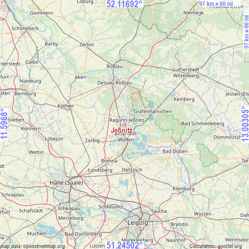
Jeßnitz GPS coordinates[2]
51° 40' 59.052" North, 12° 17' 59.712" East
| Map corner | latitude | longitude |
|---|---|---|
| Upper-left | 52.11692°, | 11.5968° |
| Center: | 51.68307°, | 12.29992° |
| Lower-right: | 51.24502°, | 13.00305° |
| Map W x H: | 96.9×96.9 km | = 60.2×60.2mi |
| max Lat: | 55.01917° ⇑31.3% North |
| Jeßnitz: | 51.68307° |
| min Lat: | ⇓68.7% South 47.40724° |
| min Long | Jeßnitz | max Long |
| 5.92978° | 12.29992° | 14.98853° |
| W 85.8%⇐ | ⇒14.2% E |
Elevation
Elevation of Jeßnitz is 75 m = 246 ft, and this is 174.1 m = 571 ft below average elevation for this country.
| Max E: |
1256 m = 4121 ft | 72.4% |
| Avg. | 249.1 m = 817 ft | |
| Jeßnitz | 75 m = 246 ft | |
Min E: |
-5 m = -16 ft | 27.6% |
See also: Germany elevation on elevation.city.
Geographical zone
Jeßnitz is located in North temperate zone (between Tropic of Cancer and the Arctic Circle). Distance of this North polar circle is 1654.6 km =1028.1 mi to North.| Distance of | km | miles | from Jeßnitz |
|---|---|---|---|
| North Pole | 4260.4 | 2647.3 | to North |
| Arctic Circle | 1654.6 | 1028.1 | to North |
| Tropic Cancer | 3140.7 | 1951.5 | to South |
| Equator | 5746.6 | 3570.8 | to South |


Nearby cities:
15 places around Jeßnitz: (largest is in red/bold)
• Bitterfeld-Wolfen
6.8 km =4.2 mi,  165°
165°
• Bobbau
2 km =1.2 mi,  284°
284°
• Burgkemnitz
7 km =4.3 mi,  89°
89°
• Friedersdorf
6 km =3.7 mi,  130°
130°
• Greppin
4 km =2.5 mi,  179°
179°
• Muldenstein
3.4 km =2.1 mi,  111°
111°
• Möhlau
6.5 km =4 mi,  34°
34°
• Mühlbeck
7.5 km =4.7 mi, 131°
• Raguhn
3.6 km =2.2 mi,  331°
331°
• Sandersdorf
6.5 km =4 mi,  201°
201°
• Schierau
7.4 km =4.6 mi,  351°
351°
• Thalheim
6 km =3.7 mi,  235°
235°
• Wolfen
3.2 km =2 mi,  221°
221°
• Zscherndorf
8.3 km =5.2 mi, 195°
• Zschornewitz
7.8 km =4.8 mi,  62°
62°
Sources, notices
• [Note1] Compared only with cities in Germany existing in our database
• [Src1] Map data: © OpenStreetMap contributors (CC-BY-SA)
• [Src2] Other city data from geonames.org with taken over terms of usage.
• [Src3] Geographical zone / Annual Mean Temperature by Robert A. Rohde @ Wikipedia
