Greppin geodata
Greppin (Saxony-Anhalt) is a populated place; located in Germany in Europe/Berlin (GMT+2) time zone. With population of 2,840 people, there are 4140 cities with bigger population in this country. Compared to other cities in Germany, 68.2% of cities are located further ↓South; 85.8% of cities are located further ←West and 72.1% of cities have higher elevation than Greppin. Note1
Administrative division(s):
- Level 1: Saxony-Anhalt
- Level 3: Anhalt-Bitterfeld
- Level 4: Bitterfeld-Wolfen


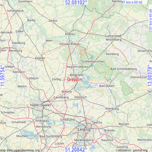
Greppin GPS coordinates[2]
51° 38' 48.552" North, 12° 18' 2.376" East
| Map corner | latitude | longitude |
|---|---|---|
| Upper-left | 52.08102°, | 11.59754° |
| Center: | 51.64682°, | 12.30066° |
| Lower-right: | 51.20842°, | 13.00379° |
| Map W x H: | 97×97 km | = 60.3×60.3mi |
| max Lat: | 55.01917° ⇑31.8% North |
| Greppin: | 51.64682° |
| min Lat: | ⇓68.2% South 47.40724° |
| min Long | Greppin | max Long |
| 5.92978° | 12.30066° | 14.98853° |
| W 85.8%⇐ | ⇒14.2% E |
Elevation
Elevation of Greppin is 77 m = 253 ft, and this is 172.1 m = 565 ft below average elevation for this country.
| Max E: |
1256 m = 4121 ft | 72.1% |
| Avg. | 249.1 m = 817 ft | |
| Greppin | 77 m = 253 ft | |
Min E: |
-5 m = -16 ft | 27.9% |
See also: Germany elevation on elevation.city.
Geographical zone
Greppin is located in North temperate zone (between Tropic of Cancer and the Arctic Circle). Distance of this North polar circle is 1658.6 km =1030.6 mi to North.| Distance of | km | miles | from Greppin |
|---|---|---|---|
| North Pole | 4264.5 | 2649.8 | to North |
| Arctic Circle | 1658.6 | 1030.6 | to North |
| Tropic Cancer | 3136.7 | 1949.1 | to South |
| Equator | 5742.6 | 3568.3 | to South |


Nearby cities:
15 places around Greppin: (largest is in red/bold)
• Bitterfeld-Wolfen
3 km =1.9 mi,  148°
148°
• Bobbau
4.9 km =3 mi,  336°
336°
• Friedersdorf
4.5 km =2.8 mi,  88°
88°
• Holzweißig
5.4 km =3.4 mi,  174°
174°
• Jeßnitz
4 km =2.5 mi,  359°
359°
• Muldenstein
4.2 km =2.6 mi,  47°
47°
• Mühlbeck
5.6 km =3.5 mi,  99°
99°
• Pouch
7.4 km =4.6 mi,  110°
110°
• Raguhn
7.4 km =4.6 mi,  346°
346°
• Ramsin
5.9 km =3.7 mi,  227°
227°
• Renneritz
7.2 km =4.5 mi, 225°
• Sandersdorf
3.2 km =2 mi, 230°
• Thalheim
5.1 km =3.2 mi,  277°
277°
• Wolfen
2.7 km =1.7 mi,  306°
306°
• Zscherndorf
4.6 km =2.9 mi,  209°
209°
Sources, notices
• [Note1] Compared only with cities in Germany existing in our database
• [Src1] Map data: © OpenStreetMap contributors (CC-BY-SA)
• [Src2] Other city data from geonames.org with taken over terms of usage.
• [Src3] Geographical zone / Annual Mean Temperature by Robert A. Rohde @ Wikipedia
