Marktbergel geodata
Marktbergel (Bavaria) is a populated place; located in Germany in Europe/Berlin (GMT+2) time zone. With population of 1,687 people, there are 5535 cities with bigger population in this country. Compared to other cities in Germany, 76.6% of cities are located further ↑North; 56.6% of cities are located further ←West and 70.7% of cities have lower elevation than Marktbergel. Note1
Administrative division(s):
- Level 1: Bavaria
- Level 2: Regierungsbezirk Mittelfranken
- Level 3: Landkreis Neustadt an der Aisch-Bad Windsheim
- Level 4: Marktbergel, Markt


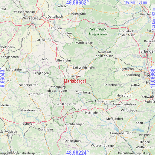
Marktbergel GPS coordinates[2]
49° 26' 29.616" North, 10° 21' 48.78" East
| Map corner | latitude | longitude |
|---|---|---|
| Upper-left | 49.89662°, | 9.66043° |
| Center: | 49.44156°, | 10.36355° |
| Lower-right: | 48.98224°, | 11.06668° |
| Map W x H: | 101.7×101.7 km | = 63.2×63.2mi |
| max Lat: | 55.01917° ⇑76.6% North |
| Marktbergel: | 49.44156° |
| min Lat: | ⇓23.4% South 47.40724° |
| min Long | Marktbergel | max Long |
| 5.92978° | 10.36355° | 14.98853° |
| W 56.6%⇐ | ⇒43.4% E |
Elevation
Elevation of Marktbergel is 364 m = 1194 ft, and this is 114.9 m = 377 ft above average elevation for this country.
| Max E: |
1256 m = 4121 ft | 29.3% |
| Marktbergel | 364 m 1194 ft | |
| Avg. | 249.1 m = 817 ft | |
Min E: |
-5 m = -16 ft | 70.7% |
See also: Germany elevation on elevation.city.
Geographical zone
Marktbergel is located in North temperate zone (between Tropic of Cancer and the Arctic Circle). Distance of this North polar circle is 1903.8 km =1183 mi to North.| Distance of | km | miles | from Marktbergel |
|---|---|---|---|
| North Pole | 4509.7 | 2802.2 | to North |
| Arctic Circle | 1903.8 | 1183 | to North |
| Tropic Cancer | 2891.5 | 1796.7 | to South |
| Equator | 5497.4 | 3415.9 | to South |


Nearby cities:
15 places around Marktbergel: (largest is in red/bold)
• Bad Windsheim
7.8 km =4.8 mi,  28°
28°
• Buch am Wald
12.6 km =7.8 mi,  189°
189°
• Burgbernheim
3.1 km =1.9 mi,  290°
290°
• Colmberg
10.3 km =6.4 mi,  160°
160°
• Ergersheim
8.6 km =5.3 mi,  345°
345°
• Flachslanden
11.8 km =7.3 mi,  113°
113°
• Gallmersgarten
7.1 km =4.4 mi,  277°
277°
• Geslau
9.1 km =5.7 mi,  202°
202°
• Illesheim
4.5 km =2.8 mi,  16°
16°
• Neusitz
12.6 km =7.8 mi,  232°
232°
• Oberdachstetten
5.8 km =3.6 mi,  118°
118°
• Obernzenn
7.5 km =4.7 mi,  81°
81°
• Ohrenbach
11.6 km =7.2 mi, 286°
• Steinsfeld
11 km =6.8 mi,  255°
255°
• Windelsbach
6.5 km =4 mi,  224°
224°
Sources, notices
• [Note1] Compared only with cities in Germany existing in our database
• [Src1] Map data: © OpenStreetMap contributors (CC-BY-SA)
• [Src2] Other city data from geonames.org with taken over terms of usage.
• [Src3] Geographical zone / Annual Mean Temperature by Robert A. Rohde @ Wikipedia
