Adelshofen geodata
Adelshofen (Bavaria) is a seat of a fourth-order administrative division; located in Germany in Europe/Berlin (GMT+2) time zone. With population of 952 people, there are 7340 cities with bigger population in this country. Compared to other cities in Germany, 76.8% of cities are located further ↑North; 52.7% of cities are located further ←West and 78.5% of cities have lower elevation than Adelshofen. Note1
Administrative division(s):
- Level 1: Bavaria
- Level 2: Regierungsbezirk Mittelfranken
- Level 3: Landkreis Ansbach
- Level 4: Adelshofen


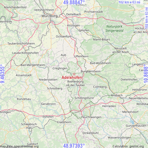
Adelshofen GPS coordinates[2]
49° 25' 59.988" North, 10° 10' 0.012" East
| Map corner | latitude | longitude |
|---|---|---|
| Upper-left | 49.88847°, | 9.46355° |
| Center: | 49.43333°, | 10.16667° |
| Lower-right: | 48.97393°, | 10.8698° |
| Map W x H: | 101.7×101.7 km | = 63.2×63.2mi |
| max Lat: | 55.01917° ⇑76.8% North |
| Adelshofen: | 49.43333° |
| min Lat: | ⇓23.2% South 47.40724° |
| min Long | Adelshofen | max Long |
| 5.92978° | 10.16667° | 14.98853° |
| W 52.7%⇐ | ⇒47.3% E |
Elevation
Elevation of Adelshofen is 423 m = 1388 ft, and this is 173.9 m = 571 ft above average elevation for this country.
| Max E: |
1256 m = 4121 ft | 21.5% |
| Adelshofen | 423 m 1388 ft | |
| Avg. | 249.1 m = 817 ft | |
Min E: |
-5 m = -16 ft | 78.5% |
See also: Germany elevation on elevation.city.
Geographical zone
Adelshofen is located in North temperate zone (between Tropic of Cancer and the Arctic Circle). Distance of this North polar circle is 1904.7 km =1183.5 mi to North.| Distance of | km | miles | from Adelshofen |
|---|---|---|---|
| North Pole | 4510.6 | 2802.8 | to North |
| Arctic Circle | 1904.7 | 1183.5 | to North |
| Tropic Cancer | 2890.6 | 1796.1 | to South |
| Equator | 5496.5 | 3415.4 | to South |


Nearby cities:
15 places around Adelshofen: (largest is in red/bold)
• Bieberehren
14.7 km =9.1 mi,  309°
309°
• Burgbernheim
11.5 km =7.1 mi,  80°
80°
• Creglingen
10.6 km =6.6 mi,  292°
292°
• Diebach
13.9 km =8.6 mi,  172°
172°
• Gallmersgarten
7.5 km =4.7 mi, 75°
• Gebsattel
9.6 km =6 mi, 165°
• Geslau
13.1 km =8.1 mi,  124°
124°
• Marktbergel
14.3 km =8.9 mi,  86°
86°
• Neusitz
8.1 km =5 mi,  148°
148°
• Ohrenbach
5.2 km =3.2 mi,  37°
37°
• Rothenburg ob der Tauber
6.2 km =3.9 mi, 166°
• Simmershofen
11.4 km =7.1 mi,  347°
347°
• Steinsfeld
4.1 km =2.5 mi, 117°
• Uffenheim
13.2 km =8.2 mi,  21°
21°
• Windelsbach
10.3 km =6.4 mi,  111°
111°
Sources, notices
• [Note1] Compared only with cities in Germany existing in our database
• [Src1] Map data: © OpenStreetMap contributors (CC-BY-SA)
• [Src2] Other city data from geonames.org with taken over terms of usage.
• [Src3] Geographical zone / Annual Mean Temperature by Robert A. Rohde @ Wikipedia
