Langenburg geodata
Langenburg (Baden-Württemberg) is a populated place; located in Germany in Europe/Berlin (GMT+2) time zone. With population of 1,817 people, there are 5320 cities with bigger population in this country. Compared to other cities in Germany, 79.4% of cities are located further ↑North; 52% of cities are located further →East and 84.4% of cities have lower elevation than Langenburg. Note1
Administrative division(s):
- Level 1: Baden-Württemberg
- Level 2: Regierungsbezirk Stuttgart
- Level 3: Landkreis Schwäbisch Hall
- Level 4: Langenburg


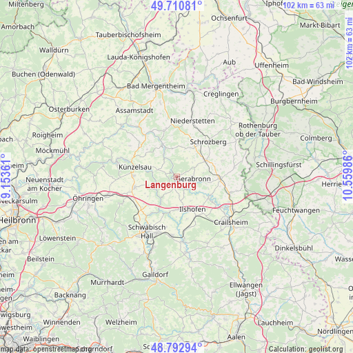
Langenburg GPS coordinates[2]
49° 15' 14.436" North, 9° 51' 24.228" East
| Map corner | latitude | longitude |
|---|---|---|
| Upper-left | 49.71081°, | 9.15361° |
| Center: | 49.25401°, | 9.85673° |
| Lower-right: | 48.79294°, | 10.55986° |
| Map W x H: | 102.1×102.1 km | = 63.4×63.4mi |
| max Lat: | 55.01917° ⇑79.4% North |
| Langenburg: | 49.25401° |
| min Lat: | ⇓20.6% South 47.40724° |
| min Long | Langenburg | max Long |
| 5.92978° | 9.85673° | 14.98853° |
| W 48%⇐ | ⇒52% E |
Elevation
Elevation of Langenburg is 464 m = 1522 ft, and this is 214.9 m = 705 ft above average elevation for this country.
| Max E: |
1256 m = 4121 ft | 15.6% |
| Langenburg | 464 m 1522 ft | |
| Avg. | 249.1 m = 817 ft | |
Min E: |
-5 m = -16 ft | 84.4% |
See also: Germany elevation on elevation.city.
Geographical zone
Langenburg is located in North temperate zone (between Tropic of Cancer and the Arctic Circle). Distance of this North polar circle is 1924.6 km =1195.9 mi to North.| Distance of | km | miles | from Langenburg |
|---|---|---|---|
| North Pole | 4530.5 | 2815.1 | to North |
| Arctic Circle | 1924.6 | 1195.9 | to North |
| Tropic Cancer | 2870.6 | 1783.7 | to South |
| Equator | 5476.5 | 3402.9 | to South |


Nearby cities:
15 places around Langenburg: (largest is in red/bold)
• Blaufelden
9.8 km =6.1 mi,  60°
60°
• Braunsbach
7.8 km =4.8 mi,  218°
218°
• Ilshofen
10.3 km =6.4 mi,  154°
154°
• Ingelfingen
15.6 km =9.7 mi,  289°
289°
• Kirchberg an der Jagst
10.9 km =6.8 mi,  123°
123°
• Kupferzell
12.4 km =7.7 mi,  256°
256°
• Künzelsau
12.9 km =8 mi,  283°
283°
• Mulfingen
10.4 km =6.5 mi,  337°
337°
• Niederstetten
16.9 km =10.5 mi,  15°
15°
• Rot am See
11.6 km =7.2 mi,  92°
92°
• Schrozberg
13.5 km =8.4 mi,  41°
41°
• Untermünkheim
14.4 km =8.9 mi, 218°
• Waldenburg
17.5 km =10.9 mi,  243°
243°
• Wallhausen
15.7 km =9.8 mi,  107°
107°
• Wolpertshausen
9.7 km =6 mi,  185°
185°
Sources, notices
• [Note1] Compared only with cities in Germany existing in our database
• [Src1] Map data: © OpenStreetMap contributors (CC-BY-SA)
• [Src2] Other city data from geonames.org with taken over terms of usage.
• [Src3] Geographical zone / Annual Mean Temperature by Robert A. Rohde @ Wikipedia
