Schrozberg geodata
Schrozberg (Baden-Württemberg) is a populated place; located in Germany in Europe/Berlin (GMT+2) time zone. With population of 6,082 people, there are 2436 cities with bigger population in this country. Compared to other cities in Germany, 78% of cities are located further ↑North; 50.4% of cities are located further →East and 83.9% of cities have lower elevation than Schrozberg. Note1
Administrative division(s):
- Level 1: Baden-Württemberg
- Level 2: Regierungsbezirk Stuttgart
- Level 3: Landkreis Schwäbisch Hall
- Level 4: Schrozberg


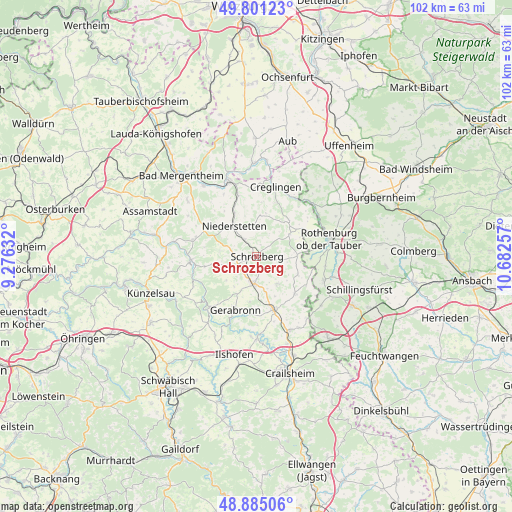
Schrozberg GPS coordinates[2]
49° 20' 43.008" North, 9° 58' 45.984" East
| Map corner | latitude | longitude |
|---|---|---|
| Upper-left | 49.80123°, | 9.27632° |
| Center: | 49.34528°, | 9.97944° |
| Lower-right: | 48.88506°, | 10.68257° |
| Map W x H: | 101.9×101.9 km | = 63.3×63.3mi |
| max Lat: | 55.01917° ⇑78% North |
| Schrozberg: | 49.34528° |
| min Lat: | ⇓22% South 47.40724° |
| min Long | Schrozberg | max Long |
| 5.92978° | 9.97944° | 14.98853° |
| W 49.6%⇐ | ⇒50.4% E |
Elevation
Elevation of Schrozberg is 461 m = 1512 ft, and this is 211.9 m = 695 ft above average elevation for this country.
| Max E: |
1256 m = 4121 ft | 16.1% |
| Schrozberg | 461 m 1512 ft | |
| Avg. | 249.1 m = 817 ft | |
Min E: |
-5 m = -16 ft | 83.9% |
See also: Germany elevation on elevation.city.
Geographical zone
Schrozberg is located in North temperate zone (between Tropic of Cancer and the Arctic Circle). Distance of this North polar circle is 1914.5 km =1189.6 mi to North.| Distance of | km | miles | from Schrozberg |
|---|---|---|---|
| North Pole | 4520.4 | 2808.8 | to North |
| Arctic Circle | 1914.5 | 1189.6 | to North |
| Tropic Cancer | 2880.8 | 1790 | to South |
| Equator | 5486.7 | 3409.3 | to South |


Nearby cities:
15 places around Schrozberg: (largest is in red/bold)
• Adelshofen
16.7 km =10.4 mi,  54°
54°
• Blaufelden
5.3 km =3.3 mi,  184°
184°
• Creglingen
14.3 km =8.9 mi,  15°
15°
• Diebach
15.9 km =9.9 mi,  104°
104°
• Gebsattel
16 km =9.9 mi,  88°
88°
• Insingen
14.5 km =9 mi,  110°
110°
• Kirchberg an der Jagst
16.1 km =10 mi, 179°
• Langenburg
13.5 km =8.4 mi,  221°
221°
• Mulfingen
13 km =8.1 mi,  267°
267°
• Niederstetten
7.5 km =4.7 mi,  324°
324°
• Rot am See
10.9 km =6.8 mi,  165°
165°
• Rothenburg ob der Tauber
15.5 km =9.6 mi,  76°
76°
• Wallhausen
16.2 km =10.1 mi,  158°
158°
• Weikersheim
15.9 km =9.9 mi,  338°
338°
• Wettringen
16.1 km =10 mi,  127°
127°
Sources, notices
• [Note1] Compared only with cities in Germany existing in our database
• [Src1] Map data: © OpenStreetMap contributors (CC-BY-SA)
• [Src2] Other city data from geonames.org with taken over terms of usage.
• [Src3] Geographical zone / Annual Mean Temperature by Robert A. Rohde @ Wikipedia
