Donndorf geodata
Donndorf (Thuringia) is a seat of a fourth-order administrative division; located in Germany in Europe/Berlin (GMT+2) time zone. With population of 836 people, there are 7754 cities with bigger population in this country. Compared to other cities in Germany, 63.1% of cities are located further ↓South; 72.4% of cities are located further ←West and 65% of cities have higher elevation than Donndorf. Note1
Administrative division(s):
- Level 1: Thuringia
- Level 3: Kyffhäuserkreis
- Level 4: Stadt Roßleben-Wiehe


Donndorf GPS coordinates[2]
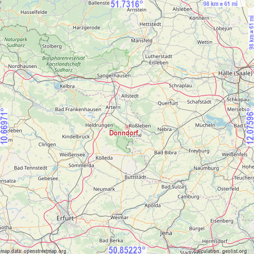
51° 17' 38.472" North, 11° 22' 22.188" East
| Map corner | latitude | longitude |
|---|---|---|
| Upper-left | 51.7316°, | 10.66971° |
| Center: | 51.29402°, | 11.37283° |
| Lower-right: | 50.85223°, | 12.07596° |
| Map W x H: | 97.8×97.8 km | = 60.8×60.8mi |
| max Lat: | 55.01917° ⇑36.9% North |
| Donndorf: | 51.29402° |
| min Lat: | ⇓63.1% South 47.40724° |
| min Long | Donndorf | max Long |
| 5.92978° | 11.37283° | 14.98853° |
| W 72.4%⇐ | ⇒27.6% E |
Elevation
Elevation of Donndorf is 120 m = 394 ft, and this is 129.1 m = 424 ft below average elevation for this country.
| Max E: |
1256 m = 4121 ft | 65% |
| Avg. | 249.1 m = 817 ft | |
| Donndorf | 120 m = 394 ft | |
Min E: |
-5 m = -16 ft | 35% |
See also: Germany elevation on elevation.city.
Geographical zone
Donndorf is located in North temperate zone (between Tropic of Cancer and the Arctic Circle). Distance of this North polar circle is 1697.8 km =1055 mi to North.| Distance of | km | miles | from Donndorf |
|---|---|---|---|
| North Pole | 4303.7 | 2674.2 | to North |
| Arctic Circle | 1697.8 | 1055 | to North |
| Tropic Cancer | 3097.4 | 1924.6 | to South |
| Equator | 5703.4 | 3543.9 | to South |


Nearby cities:
15 places around Donndorf: (largest is in red/bold)
• Artern
9.6 km =6 mi,  324°
324°
• Gehofen
4.9 km =3 mi,  310°
310°
• Hauteroda
6.9 km =4.3 mi,  243°
243°
• Heygendorf
6.4 km =4 mi,  352°
352°
• Kalbsrieth
5.8 km =3.6 mi,  337°
337°
• Lossa
8.4 km =5.2 mi,  161°
161°
• Memleben
8.9 km =5.5 mi,  110°
110°
• Nausitz
3.7 km =2.3 mi, 312°
• Oberheldrungen
8.6 km =5.3 mi,  262°
262°
• Reinsdorf
8.6 km =5.3 mi,  300°
300°
• Roßleben
4.3 km =2.7 mi,  82°
82°
• Schönewerda
3.3 km =2.1 mi, 352°
• Wiehe
4.2 km =2.6 mi,  138°
138°
• Wohlmirstedt
8 km =5 mi,  129°
129°
• Ziegelroda
7.8 km =4.8 mi,  56°
56°
Sources, notices
• [Note1] Compared only with cities in Germany existing in our database
• [Src1] Map data: © OpenStreetMap contributors (CC-BY-SA)
• [Src2] Other city data from geonames.org with taken over terms of usage.
• [Src3] Geographical zone / Annual Mean Temperature by Robert A. Rohde @ Wikipedia
