Röllbach geodata
Röllbach (Bavaria) is a seat of a fourth-order administrative division; located in Germany in Europe/Berlin (GMT+2) time zone. With population of 1,719 people, there are 5477 cities with bigger population in this country. Compared to other cities in Germany, 69.6% of cities are located further ↑North; 61.6% of cities are located further →East and 51% of cities have higher elevation than Röllbach. Note1
Administrative division(s):
- Level 1: Bavaria
- Level 2: Regierungsbezirk Unterfranken
- Level 3: Landkreis Miltenberg
- Level 4: Röllbach


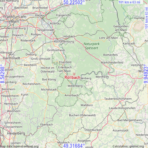
Röllbach GPS coordinates[2]
49° 46' 23.016" North, 9° 14' 45.996" East
| Map corner | latitude | longitude |
|---|---|---|
| Upper-left | 50.22502°, | 8.54298° |
| Center: | 49.77306°, | 9.24611° |
| Lower-right: | 49.31684°, | 9.94923° |
| Map W x H: | 101×101 km | = 62.8×62.8mi |
| max Lat: | 55.01917° ⇑69.6% North |
| Röllbach: | 49.77306° |
| min Lat: | ⇓30.4% South 47.40724° |
| min Long | Röllbach | max Long |
| 5.92978° | 9.24611° | 14.98853° |
| W 38.4%⇐ | ⇒61.6% E |
Elevation
Elevation of Röllbach is 218 m = 715 ft, and this is 31.1 m = 102 ft below average elevation for this country.
| Max E: |
1256 m = 4121 ft | 51% |
| Avg. | 249.1 m = 817 ft | |
| Röllbach | 218 m = 715 ft | |
Min E: |
-5 m = -16 ft | 49% |
See also: Germany elevation on elevation.city.
Geographical zone
Röllbach is located in North temperate zone (between Tropic of Cancer and the Arctic Circle). Distance of this North polar circle is 1866.9 km =1160 mi to North.| Distance of | km | miles | from Röllbach |
|---|---|---|---|
| North Pole | 4472.8 | 2779.3 | to North |
| Arctic Circle | 1866.9 | 1160 | to North |
| Tropic Cancer | 2928.3 | 1819.6 | to South |
| Equator | 5534.2 | 3438.8 | to South |


Nearby cities:
15 places around Röllbach: (largest is in red/bold)
• Bürgstadt
6.7 km =4.2 mi,  165°
165°
• Dorfprozelten
9.7 km =6 mi,  85°
85°
• Eichenbühl
9.6 km =6 mi,  141°
141°
• Elsenfeld
9.8 km =6.1 mi,  322°
322°
• Erlenbach am Main
6.8 km =4.2 mi,  299°
299°
• Eschau
5.2 km =3.2 mi,  10°
10°
• Freudenberg
6.2 km =3.9 mi,  110°
110°
• Großheubach
5.2 km =3.2 mi,  198°
198°
• Kleinheubach
6.2 km =3.9 mi, 202°
• Klingenberg am Main
4.9 km =3 mi,  285°
285°
• Laudenbach
5.9 km =3.7 mi,  238°
238°
• Miltenberg
7.8 km =4.8 mi, 168°
• Mönchberg
2.8 km =1.7 mi,  35°
35°
• Rüdenau
8.4 km =5.2 mi,  215°
215°
• Wörth am Main
7.1 km =4.4 mi, 292°
Sources, notices
• [Note1] Compared only with cities in Germany existing in our database
• [Src1] Map data: © OpenStreetMap contributors (CC-BY-SA)
• [Src2] Other city data from geonames.org with taken over terms of usage.
• [Src3] Geographical zone / Annual Mean Temperature by Robert A. Rohde @ Wikipedia
