Großheubach geodata
Großheubach (Bavaria) is a populated place; located in Germany in Europe/Berlin (GMT+2) time zone. With population of 5,126 people, there are 2777 cities with bigger population in this country. Compared to other cities in Germany, 70.7% of cities are located further ↑North; 61.9% of cities are located further →East and 62.9% of cities have higher elevation than Großheubach. Note1
Administrative division(s):
- Level 1: Bavaria
- Level 2: Regierungsbezirk Unterfranken
- Level 3: Landkreis Miltenberg
- Level 4: Großheubach, Markt


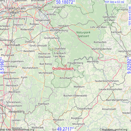
Großheubach GPS coordinates[2]
49° 43' 42.024" North, 9° 13' 22.08" East
| Map corner | latitude | longitude |
|---|---|---|
| Upper-left | 50.18072°, | 8.51967° |
| Center: | 49.72834°, | 9.2228° |
| Lower-right: | 49.2717°, | 9.92592° |
| Map W x H: | 101.1×101.1 km | = 62.8×62.8mi |
| max Lat: | 55.01917° ⇑70.7% North |
| Großheubach: | 49.72834° |
| min Lat: | ⇓29.3% South 47.40724° |
| min Long | Großheubach | max Long |
| 5.92978° | 9.2228° | 14.98853° |
| W 38.1%⇐ | ⇒61.9% E |
Elevation
Elevation of Großheubach is 133 m = 436 ft, and this is 116.1 m = 381 ft below average elevation for this country.
| Max E: |
1256 m = 4121 ft | 62.9% |
| Avg. | 249.1 m = 817 ft | |
| Großheubach | 133 m = 436 ft | |
Min E: |
-5 m = -16 ft | 37.1% |
See also: Germany elevation on elevation.city.
Geographical zone
Großheubach is located in North temperate zone (between Tropic of Cancer and the Arctic Circle). Distance of this North polar circle is 1871.9 km =1163.1 mi to North.| Distance of | km | miles | from Großheubach |
|---|---|---|---|
| North Pole | 4477.8 | 2782.4 | to North |
| Arctic Circle | 1871.9 | 1163.1 | to North |
| Tropic Cancer | 2923.4 | 1816.5 | to South |
| Equator | 5529.3 | 3435.7 | to South |


Nearby cities:
15 places around Großheubach: (largest is in red/bold)
• Bürgstadt
3.7 km =2.3 mi,  114°
114°
• Eichenbühl
8.1 km =5 mi, 108°
• Erlenbach am Main
9.4 km =5.8 mi,  332°
332°
• Eschau
10.4 km =6.5 mi,  14°
14°
• Freudenberg
8 km =5 mi,  69°
69°
• Kleinheubach
1 km =0.6 mi,  219°
219°
• Klingenberg am Main
7 km =4.3 mi, 334°
• Laudenbach
3.9 km =2.4 mi,  300°
300°
• Lützelbach
12.5 km =7.8 mi, 302°
• Miltenberg
4.2 km =2.6 mi,  129°
129°
• Mönchberg
7.9 km =4.9 mi,  24°
24°
• Röllbach
5.2 km =3.2 mi, 18°
• Rüdenau
3.7 km =2.3 mi,  238°
238°
• Weilbach
6.7 km =4.2 mi,  183°
183°
• Wörth am Main
9.1 km =5.7 mi, 327°
Sources, notices
• [Note1] Compared only with cities in Germany existing in our database
• [Src1] Map data: © OpenStreetMap contributors (CC-BY-SA)
• [Src2] Other city data from geonames.org with taken over terms of usage.
• [Src3] Geographical zone / Annual Mean Temperature by Robert A. Rohde @ Wikipedia
