Mönchberg geodata
Mönchberg (Bavaria) is a populated place; located in Germany in Europe/Berlin (GMT+2) time zone. With population of 2,530 people, there are 4402 cities with bigger population in this country. Compared to other cities in Germany, 69.2% of cities are located further ↑North; 61.2% of cities are located further →East and 55.2% of cities have lower elevation than Mönchberg. Note1
Administrative division(s):
- Level 1: Bavaria
- Level 2: Regierungsbezirk Unterfranken
- Level 3: Landkreis Miltenberg
- Level 4: Mönchberg, Markt


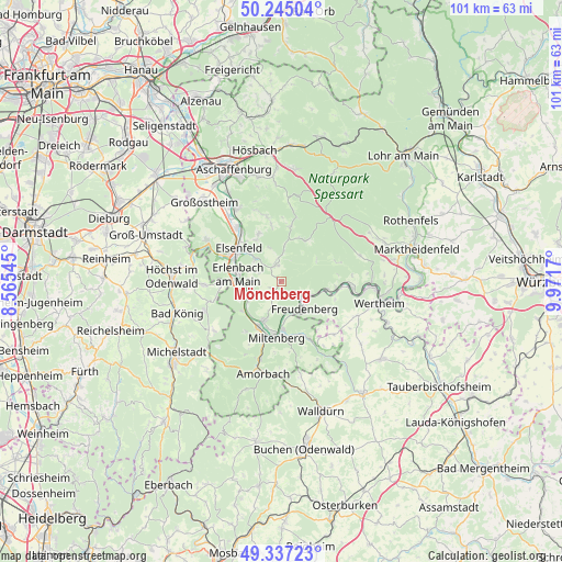
Mönchberg GPS coordinates[2]
49° 47' 35.736" North, 9° 16' 6.888" East
| Map corner | latitude | longitude |
|---|---|---|
| Upper-left | 50.24504°, | 8.56545° |
| Center: | 49.79326°, | 9.26858° |
| Lower-right: | 49.33723°, | 9.9717° |
| Map W x H: | 100.9×100.9 km | = 62.7×62.7mi |
| max Lat: | 55.01917° ⇑69.2% North |
| Mönchberg: | 49.79326° |
| min Lat: | ⇓30.8% South 47.40724° |
| min Long | Mönchberg | max Long |
| 5.92978° | 9.26858° | 14.98853° |
| W 38.8%⇐ | ⇒61.2% E |
Elevation
Elevation of Mönchberg is 259 m = 850 ft, and this is 9.9 m = 32 ft above average elevation for this country.
| Max E: |
1256 m = 4121 ft | 44.8% |
| Mönchberg | 259 m 850 ft | |
| Avg. | 249.1 m = 817 ft | |
Min E: |
-5 m = -16 ft | 55.2% |
See also: Germany elevation on elevation.city.
Geographical zone
Mönchberg is located in North temperate zone (between Tropic of Cancer and the Arctic Circle). Distance of this North polar circle is 1864.7 km =1158.7 mi to North.| Distance of | km | miles | from Mönchberg |
|---|---|---|---|
| North Pole | 4470.6 | 2777.9 | to North |
| Arctic Circle | 1864.7 | 1158.7 | to North |
| Tropic Cancer | 2930.6 | 1821 | to South |
| Equator | 5536.5 | 3440.2 | to South |


Nearby cities:
15 places around Mönchberg: (largest is in red/bold)
• Altenbuch
10.3 km =6.4 mi,  67°
67°
• Bürgstadt
8.7 km =5.4 mi,  179°
179°
• Dorfprozelten
8.1 km =5 mi,  99°
99°
• Elsenfeld
9.3 km =5.8 mi,  306°
306°
• Erlenbach am Main
7.7 km =4.8 mi,  278°
278°
• Eschau
2.9 km =1.8 mi,  346°
346°
• Freudenberg
6.1 km =3.8 mi,  136°
136°
• Großheubach
7.9 km =4.9 mi,  204°
204°
• Hausen
9.5 km =5.9 mi,  333°
333°
• Kleinheubach
8.9 km =5.5 mi,  206°
206°
• Klingenberg am Main
6.4 km =4 mi,  261°
261°
• Laudenbach
8.5 km =5.3 mi,  231°
231°
• Miltenberg
9.9 km =6.2 mi, 180°
• Röllbach
2.8 km =1.7 mi,  215°
215°
• Wörth am Main
8.2 km =5.1 mi,  273°
273°
Sources, notices
• [Note1] Compared only with cities in Germany existing in our database
• [Src1] Map data: © OpenStreetMap contributors (CC-BY-SA)
• [Src2] Other city data from geonames.org with taken over terms of usage.
• [Src3] Geographical zone / Annual Mean Temperature by Robert A. Rohde @ Wikipedia
