Eschau geodata
Eschau (Bavaria) is a populated place; located in Germany in Europe/Berlin (GMT+2) time zone. With population of 4,129 people, there are 3207 cities with bigger population in this country. Compared to other cities in Germany, 68.4% of cities are located further ↑North; 61.4% of cities are located further →East and 56.7% of cities have higher elevation than Eschau. Note1
Administrative division(s):
- Level 1: Bavaria
- Level 2: Regierungsbezirk Unterfranken
- Level 3: Landkreis Miltenberg
- Level 4: Eschau, Markt


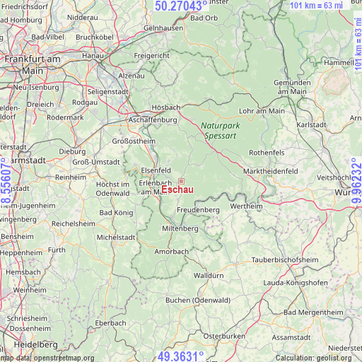
Eschau GPS coordinates[2]
49° 49' 8.004" North, 9° 15' 33.12" East
| Map corner | latitude | longitude |
|---|---|---|
| Upper-left | 50.27043°, | 8.55607° |
| Center: | 49.81889°, | 9.2592° |
| Lower-right: | 49.3631°, | 9.96232° |
| Map W x H: | 100.9×100.9 km | = 62.7×62.7mi |
| max Lat: | 55.01917° ⇑68.4% North |
| Eschau: | 49.81889° |
| min Lat: | ⇓31.6% South 47.40724° |
| min Long | Eschau | max Long |
| 5.92978° | 9.2592° | 14.98853° |
| W 38.6%⇐ | ⇒61.4% E |
Elevation
Elevation of Eschau is 177 m = 581 ft, and this is 72.1 m = 237 ft below average elevation for this country.
| Max E: |
1256 m = 4121 ft | 56.7% |
| Avg. | 249.1 m = 817 ft | |
| Eschau | 177 m = 581 ft | |
Min E: |
-5 m = -16 ft | 43.3% |
See also: Germany elevation on elevation.city.
Geographical zone
Eschau is located in North temperate zone (between Tropic of Cancer and the Arctic Circle). Distance of this North polar circle is 1861.8 km =1156.9 mi to North.| Distance of | km | miles | from Eschau |
|---|---|---|---|
| North Pole | 4467.7 | 2776.1 | to North |
| Arctic Circle | 1861.8 | 1156.9 | to North |
| Tropic Cancer | 2933.4 | 1822.7 | to South |
| Equator | 5539.3 | 3442 | to South |


Nearby cities:
15 places around Eschau: (largest is in red/bold)
• Dorfprozelten
9.7 km =6 mi,  116°
116°
• Elsenfeld
7.4 km =4.6 mi,  291°
291°
• Erlenbach am Main
7.1 km =4.4 mi,  255°
255°
• Freudenberg
8.8 km =5.5 mi,  146°
146°
• Großwallstadt
10.1 km =6.3 mi,  311°
311°
• Hausen
6.7 km =4.2 mi,  328°
328°
• Heimbuchenthal
8.2 km =5.1 mi,  18°
18°
• Kleinwallstadt
8.9 km =5.5 mi, 313°
• Klingenberg am Main
6.8 km =4.2 mi,  236°
236°
• Laudenbach
10.1 km =6.3 mi,  216°
216°
• Leidersbach
9.6 km =6 mi,  343°
343°
• Mönchberg
2.9 km =1.8 mi,  166°
166°
• Obernburg am Main
9.4 km =5.8 mi,  281°
281°
• Röllbach
5.2 km =3.2 mi,  190°
190°
• Wörth am Main
7.9 km =4.9 mi,  252°
252°
Sources, notices
• [Note1] Compared only with cities in Germany existing in our database
• [Src1] Map data: © OpenStreetMap contributors (CC-BY-SA)
• [Src2] Other city data from geonames.org with taken over terms of usage.
• [Src3] Geographical zone / Annual Mean Temperature by Robert A. Rohde @ Wikipedia
