Rüdenau geodata
Rüdenau (Bavaria) is a seat of a fourth-order administrative division; located in Germany in Europe/Berlin (GMT+2) time zone. With population of 866 people, there are 7640 cities with bigger population in this country. Compared to other cities in Germany, 71.1% of cities are located further ↑North; 62.8% of cities are located further →East and 54.2% of cities have higher elevation than Rüdenau. Note1
Administrative division(s):
- Level 1: Bavaria
- Level 2: Regierungsbezirk Unterfranken
- Level 3: Landkreis Miltenberg
- Level 4: Rüdenau


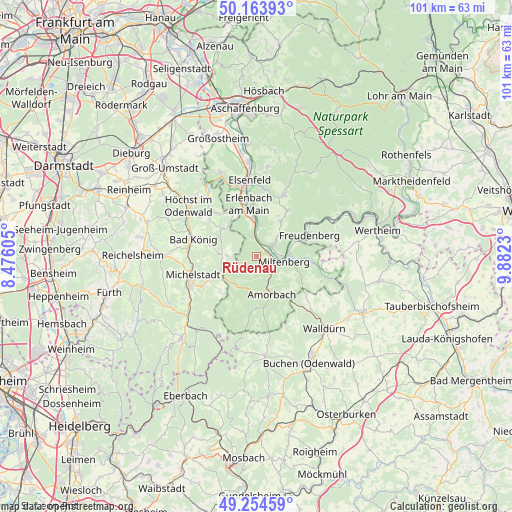
Rüdenau GPS coordinates[2]
49° 42' 41.004" North, 9° 10' 45.012" East
| Map corner | latitude | longitude |
|---|---|---|
| Upper-left | 50.16393°, | 8.47605° |
| Center: | 49.71139°, | 9.17917° |
| Lower-right: | 49.25459°, | 9.8823° |
| Map W x H: | 101.1×101.1 km | = 62.8×62.8mi |
| max Lat: | 55.01917° ⇑71.1% North |
| Rüdenau: | 49.71139° |
| min Lat: | ⇓28.9% South 47.40724° |
| min Long | Rüdenau | max Long |
| 5.92978° | 9.17917° | 14.98853° |
| W 37.2%⇐ | ⇒62.8% E |
Elevation
Elevation of Rüdenau is 195 m = 640 ft, and this is 54.1 m = 177 ft below average elevation for this country.
| Max E: |
1256 m = 4121 ft | 54.2% |
| Avg. | 249.1 m = 817 ft | |
| Rüdenau | 195 m = 640 ft | |
Min E: |
-5 m = -16 ft | 45.8% |
See also: Germany elevation on elevation.city.
Geographical zone
Rüdenau is located in North temperate zone (between Tropic of Cancer and the Arctic Circle). Distance of this North polar circle is 1873.8 km =1164.3 mi to North.| Distance of | km | miles | from Rüdenau |
|---|---|---|---|
| North Pole | 4479.7 | 2783.6 | to North |
| Arctic Circle | 1873.8 | 1164.3 | to North |
| Tropic Cancer | 2921.5 | 1815.3 | to South |
| Equator | 5527.4 | 3434.6 | to South |


Nearby cities:
15 places around Rüdenau: (largest is in red/bold)
• Bürgstadt
6.5 km =4 mi,  86°
86°
• Eichenbühl
10.8 km =6.7 mi, 93°
• Erlenbach am Main
10.3 km =6.4 mi,  353°
353°
• Großheubach
3.7 km =2.3 mi,  58°
58°
• Kirchzell
10.4 km =6.5 mi,  180°
180°
• Kleinheubach
2.7 km =1.7 mi,  66°
66°
• Klingenberg am Main
8.2 km =5.1 mi,  0°
0°
• Laudenbach
3.8 km =2.4 mi,  356°
356°
• Lützelbach
11.4 km =7.1 mi,  318°
318°
• Miltenberg
6.4 km =4 mi,  96°
96°
• Mönchberg
11.1 km =6.9 mi,  35°
35°
• Röllbach
8.4 km =5.2 mi, 35°
• Weilbach
5.5 km =3.4 mi,  150°
150°
• Weiten-Gesäß
9.3 km =5.8 mi,  263°
263°
• Wörth am Main
9.7 km =6 mi, 349°
Sources, notices
• [Note1] Compared only with cities in Germany existing in our database
• [Src1] Map data: © OpenStreetMap contributors (CC-BY-SA)
• [Src2] Other city data from geonames.org with taken over terms of usage.
• [Src3] Geographical zone / Annual Mean Temperature by Robert A. Rohde @ Wikipedia
