Roggentin geodata
Roggentin (Mecklenburg-Vorpommern) is a populated place; located in Germany in Europe/Berlin (GMT+2) time zone. With population of 755 people, there are 8072 cities with bigger population in this country. Compared to other cities in Germany, 84% of cities are located further ↓South; 91.3% of cities are located further ←West and 74.1% of cities have higher elevation than Roggentin. Note1
Administrative division(s):
- Level 1: Mecklenburg-Vorpommern
- Level 3: Mecklenburgische Seenplatte
- Level 4: Mirow


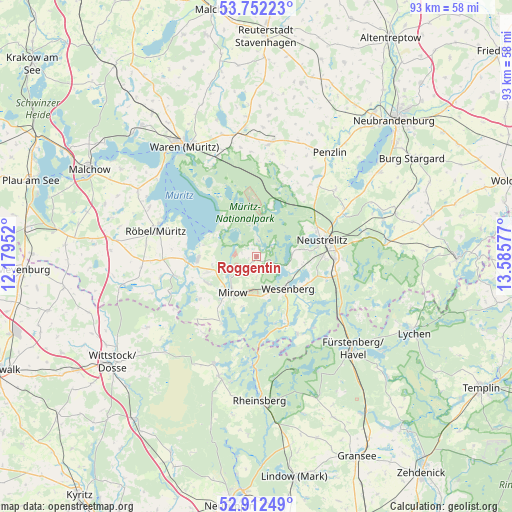
Roggentin GPS coordinates[2]
53° 20' 3.948" North, 12° 52' 57.504" East
| Map corner | latitude | longitude |
|---|---|---|
| Upper-left | 53.75223°, | 12.17952° |
| Center: | 53.33443°, | 12.88264° |
| Lower-right: | 52.91249°, | 13.58577° |
| Map W x H: | 93.4×93.4 km | = 58×58mi |
| max Lat: | 55.01917° ⇑16% North |
| Roggentin: | 53.33443° |
| min Lat: | ⇓84% South 47.40724° |
| min Long | Roggentin | max Long |
| 5.92978° | 12.88264° | 14.98853° |
| W 91.3%⇐ | ⇒8.7% E |
Elevation
Elevation of Roggentin is 67 m = 220 ft, and this is 182.1 m = 597 ft below average elevation for this country.
| Max E: |
1256 m = 4121 ft | 74.1% |
| Avg. | 249.1 m = 817 ft | |
| Roggentin | 67 m = 220 ft | |
Min E: |
-5 m = -16 ft | 25.9% |
See also: Germany elevation on elevation.city.
Geographical zone
Roggentin is located in North temperate zone (between Tropic of Cancer and the Arctic Circle). Distance of this North polar circle is 1470.9 km =914 mi to North.| Distance of | km | miles | from Roggentin |
|---|---|---|---|
| North Pole | 4076.8 | 2533.2 | to North |
| Arctic Circle | 1470.9 | 914 | to North |
| Tropic Cancer | 3324.3 | 2065.6 | to South |
| Equator | 5930.2 | 3684.9 | to South |


Nearby cities:
15 places around Roggentin: (largest is in red/bold)
• Ankershagen
17.1 km =10.6 mi,  19°
19°
• Blumenholz
18.1 km =11.2 mi,  60°
60°
• Hohenzieritz
18.7 km =11.6 mi,  49°
49°
• Kargow
20.6 km =12.8 mi,  341°
341°
• Klein Vielen
16.3 km =10.1 mi,  36°
36°
• Klink
23.5 km =14.6 mi,  312°
312°
• Kratzeburg
11.3 km =7 mi, 20°
• Lärz
10.1 km =6.3 mi,  243°
243°
• Möllenhagen
21.3 km =13.2 mi,  8°
8°
• Neustrelitz
13 km =8.1 mi,  76°
76°
• Penzlin
23.1 km =14.4 mi, 35°
• Rechlin
10.4 km =6.5 mi,  270°
270°
• Röbel
19.1 km =11.9 mi,  283°
283°
• Userin
6.5 km =4 mi,  85°
85°
• Wesenberg
8.3 km =5.2 mi,  136°
136°
Sources, notices
• [Note1] Compared only with cities in Germany existing in our database
• [Src1] Map data: © OpenStreetMap contributors (CC-BY-SA)
• [Src2] Other city data from geonames.org with taken over terms of usage.
• [Src3] Geographical zone / Annual Mean Temperature by Robert A. Rohde @ Wikipedia
