Wesenberg geodata
Wesenberg (Mecklenburg-Vorpommern) is a populated place; located in Germany in Europe/Berlin (GMT+2) time zone. With population of 3,346 people, there are 3727 cities with bigger population in this country. Compared to other cities in Germany, 83.5% of cities are located further ↓South; 92.1% of cities are located further ←West and 76.1% of cities have higher elevation than Wesenberg. Note1
Administrative division(s):
- Level 1: Mecklenburg-Vorpommern
- Level 3: Mecklenburgische Seenplatte
- Level 4: Wesenberg


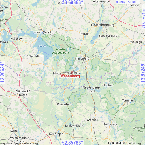
Wesenberg GPS coordinates[2]
53° 16' 49.08" North, 12° 58' 9.696" East
| Map corner | latitude | longitude |
|---|---|---|
| Upper-left | 53.69863°, | 12.26624° |
| Center: | 53.2803°, | 12.96936° |
| Lower-right: | 52.85783°, | 13.67249° |
| Map W x H: | 93.5×93.5 km | = 58.1×58.1mi |
| max Lat: | 55.01917° ⇑16.5% North |
| Wesenberg: | 53.2803° |
| min Lat: | ⇓83.5% South 47.40724° |
| min Long | Wesenberg | max Long |
| 5.92978° | 12.96936° | 14.98853° |
| W 92.1%⇐ | ⇒7.9% E |
Elevation
Elevation of Wesenberg is 59 m = 194 ft, and this is 190.1 m = 624 ft below average elevation for this country.
| Max E: |
1256 m = 4121 ft | 76.1% |
| Avg. | 249.1 m = 817 ft | |
| Wesenberg | 59 m = 194 ft | |
Min E: |
-5 m = -16 ft | 23.9% |
See also: Germany elevation on elevation.city.
Geographical zone
Wesenberg is located in North temperate zone (between Tropic of Cancer and the Arctic Circle). Distance of this North polar circle is 1477 km =917.8 mi to North.| Distance of | km | miles | from Wesenberg |
|---|---|---|---|
| North Pole | 4082.8 | 2536.9 | to North |
| Arctic Circle | 1477 | 917.8 | to North |
| Tropic Cancer | 3318.3 | 2061.9 | to South |
| Equator | 5924.2 | 3681.1 | to South |


Nearby cities:
15 places around Wesenberg: (largest is in red/bold)
• Ankershagen
22.2 km =13.8 mi,  359°
359°
• Blankensee
24.1 km =15 mi,  55°
55°
• Blumenholz
17.9 km =11.1 mi,  34°
34°
• Carpin
20.1 km =12.5 mi, 64°
• Fürstenberg
15.8 km =9.8 mi,  132°
132°
• Hohenzieritz
19.9 km =12.4 mi, 25°
• Klein Vielen
19.5 km =12.1 mi,  11°
11°
• Kratzeburg
16.7 km =10.4 mi,  353°
353°
• Lychen
24.2 km =15 mi,  108°
108°
• Lärz
14.9 km =9.3 mi,  275°
275°
• Neustrelitz
11.3 km =7 mi,  37°
37°
• Rechlin
17.3 km =10.7 mi,  290°
290°
• Rheinsberg
20.6 km =12.8 mi,  193°
193°
• Roggentin
8.3 km =5.2 mi,  316°
316°
• Userin
6.5 km =4 mi, 6°
Sources, notices
• [Note1] Compared only with cities in Germany existing in our database
• [Src1] Map data: © OpenStreetMap contributors (CC-BY-SA)
• [Src2] Other city data from geonames.org with taken over terms of usage.
• [Src3] Geographical zone / Annual Mean Temperature by Robert A. Rohde @ Wikipedia
