Mainstockheim geodata
Mainstockheim (Bavaria) is a seat of a fourth-order administrative division; located in Germany in Europe/Berlin (GMT+2) time zone. With population of 1,834 people, there are 5293 cities with bigger population in this country. Compared to other cities in Germany, 69.6% of cities are located further ↑North; 52.4% of cities are located further ←West and 52.6% of cities have higher elevation than Mainstockheim. Note1
Administrative division(s):
- Level 1: Bavaria
- Level 2: Regierungsbezirk Unterfranken
- Level 3: Landkreis Kitzingen
- Level 4: Mainstockheim


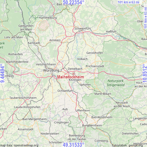
Mainstockheim GPS coordinates[2]
49° 46' 17.616" North, 10° 8' 53.052" East
| Map corner | latitude | longitude |
|---|---|---|
| Upper-left | 50.22354°, | 9.44494° |
| Center: | 49.77156°, | 10.14807° |
| Lower-right: | 49.31533°, | 10.8512° |
| Map W x H: | 101×101 km | = 62.8×62.8mi |
| max Lat: | 55.01917° ⇑69.6% North |
| Mainstockheim: | 49.77156° |
| min Lat: | ⇓30.4% South 47.40724° |
| min Long | Mainstockheim | max Long |
| 5.92978° | 10.14807° | 14.98853° |
| W 52.4%⇐ | ⇒47.6% E |
Elevation
Elevation of Mainstockheim is 207 m = 679 ft, and this is 42.1 m = 138 ft below average elevation for this country.
| Max E: |
1256 m = 4121 ft | 52.6% |
| Avg. | 249.1 m = 817 ft | |
| Mainstockheim | 207 m = 679 ft | |
Min E: |
-5 m = -16 ft | 47.4% |
See also: Germany elevation on elevation.city.
Geographical zone
Mainstockheim is located in North temperate zone (between Tropic of Cancer and the Arctic Circle). Distance of this North polar circle is 1867.1 km =1160.2 mi to North.| Distance of | km | miles | from Mainstockheim |
|---|---|---|---|
| North Pole | 4473 | 2779.4 | to North |
| Arctic Circle | 1867.1 | 1160.2 | to North |
| Tropic Cancer | 2928.2 | 1819.5 | to South |
| Equator | 5534.1 | 3438.7 | to South |


Nearby cities:
15 places around Mainstockheim: (largest is in red/bold)
• Albertshofen
1.4 km =0.9 mi,  112°
112°
• Biebelried
4.7 km =2.9 mi,  263°
263°
• Buchbrunn
1.5 km =0.9 mi,  211°
211°
• Dettelbach
3.7 km =2.3 mi,  19°
19°
• Großlangheim
6.9 km =4.3 mi,  104°
104°
• Kitzingen
3.5 km =2.2 mi,  176°
176°
• Kleinlangheim
9.8 km =6.1 mi,  90°
90°
• Mainbernheim
8.7 km =5.4 mi,  144°
144°
• Marktsteft
8.4 km =5.2 mi,  185°
185°
• Nordheim
10.1 km =6.3 mi, 15°
• Rottendorf
9.1 km =5.7 mi,  284°
284°
• Rödelsee
8.4 km =5.2 mi,  124°
124°
• Sommerach
7.7 km =4.8 mi,  33°
33°
• Sulzfeld am Main
7.3 km =4.5 mi, 188°
• Theilheim
8.7 km =5.4 mi, 256°
Sources, notices
• [Note1] Compared only with cities in Germany existing in our database
• [Src1] Map data: © OpenStreetMap contributors (CC-BY-SA)
• [Src2] Other city data from geonames.org with taken over terms of usage.
• [Src3] Geographical zone / Annual Mean Temperature by Robert A. Rohde @ Wikipedia
