Rockstedt geodata
Rockstedt (Thuringia) is a seat of a fourth-order administrative division; located in Germany in Europe/Berlin (GMT+2) time zone. With population of 263 people, there are 10196 cities with bigger population in this country. Compared to other cities in Germany, 63% of cities are located further ↓South; 63.4% of cities are located further ←West and 50.7% of cities have lower elevation than Rockstedt. Note1


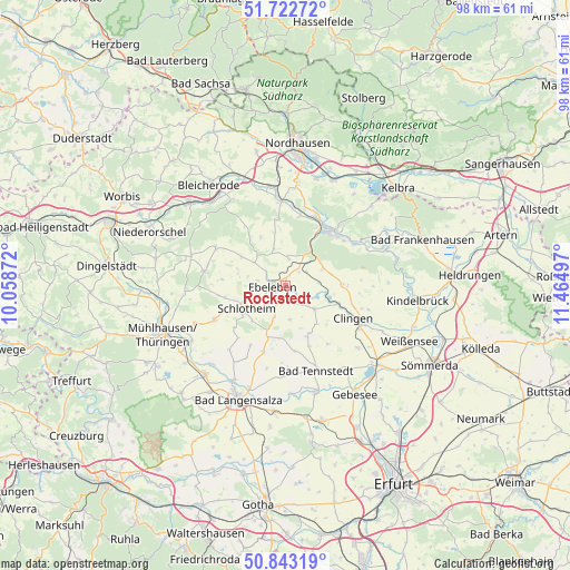
Rockstedt GPS coordinates[2]
51° 17' 6.216" North, 10° 45' 42.624" East
| Map corner | latitude | longitude |
|---|---|---|
| Upper-left | 51.72272°, | 10.05872° |
| Center: | 51.28506°, | 10.76184° |
| Lower-right: | 50.84319°, | 11.46497° |
| Map W x H: | 97.8×97.8 km | = 60.8×60.8mi |
| max Lat: | 55.01917° ⇑37% North |
| Rockstedt: | 51.28506° |
| min Lat: | ⇓63% South 47.40724° |
| min Long | Rockstedt | max Long |
| 5.92978° | 10.76184° | 14.98853° |
| W 63.4%⇐ | ⇒36.6% E |
Elevation
Elevation of Rockstedt is 231 m = 758 ft, and this is 18.1 m = 59 ft below average elevation for this country.
| Max E: |
1256 m = 4121 ft | 49.3% |
| Avg. | 249.1 m = 817 ft | |
| Rockstedt | 231 m = 758 ft | |
Min E: |
-5 m = -16 ft | 50.7% |
See also: Germany elevation on elevation.city.
Geographical zone
Rockstedt is located in North temperate zone (between Tropic of Cancer and the Arctic Circle). Distance of this North polar circle is 1698.8 km =1055.6 mi to North.| Distance of | km | miles | from Rockstedt |
|---|---|---|---|
| North Pole | 4304.7 | 2674.8 | to North |
| Arctic Circle | 1698.8 | 1055.6 | to North |
| Tropic Cancer | 3096.4 | 1924 | to South |
| Equator | 5702.4 | 3543.3 | to South |


Nearby cities:
15 places around Rockstedt: (largest is in red/bold)
• Abtsbessingen
2.6 km =1.6 mi,  178°
178°
• Bellstedt
2.5 km =1.6 mi,  143°
143°
• Blankenburg
9.5 km =5.9 mi, 184°
• Ebeleben
2.2 km =1.4 mi,  263°
263°
• Freienbessingen
5.8 km =3.6 mi, 176°
• Großenehrich
6.5 km =4 mi,  128°
128°
• Holzsußra
5.5 km =3.4 mi,  267°
267°
• Hornsömmern
8.5 km =5.3 mi,  153°
153°
• Kutzleben
9.5 km =5.9 mi, 184°
• Marolterode
7.9 km =4.9 mi,  223°
223°
• Schernberg
4.8 km =3 mi,  6°
6°
• Schlotheim
8.4 km =5.2 mi,  239°
239°
• Thüringenhausen
3.4 km =2.1 mi, 127°
• Wasserthaleben
9.3 km =5.8 mi,  114°
114°
• Wolferschwenda
6.3 km =3.9 mi,  155°
155°
Sources, notices
• [Note1] Compared only with cities in Germany existing in our database
• [Src1] Map data: © OpenStreetMap contributors (CC-BY-SA)
• [Src2] Other city data from geonames.org with taken over terms of usage.
• [Src3] Geographical zone / Annual Mean Temperature by Robert A. Rohde @ Wikipedia
