Riedering geodata
Riedering (Bavaria) is a seat of a fourth-order administrative division; located in Germany in Europe/Berlin (GMT+2) time zone. With population of 5,315 people, there are 2695 cities with bigger population in this country. Compared to other cities in Germany, 97.3% of cities are located further ↑North; 84.8% of cities are located further ←West and 87.4% of cities have lower elevation than Riedering. Note1
Administrative division(s):
- Level 1: Bavaria
- Level 2: Upper Bavaria
- Level 3: Landkreis Rosenheim
- Level 4: Riedering


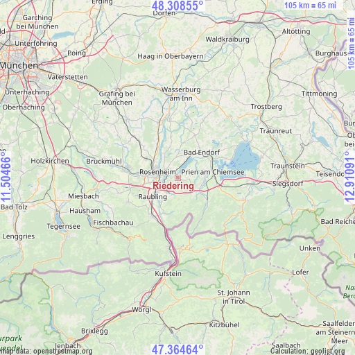
Riedering GPS coordinates[2]
47° 50' 19.464" North, 12° 12' 28.008" East
| Map corner | latitude | longitude |
|---|---|---|
| Upper-left | 48.30855°, | 11.50466° |
| Center: | 47.83874°, | 12.20778° |
| Lower-right: | 47.36464°, | 12.91091° |
| Map W x H: | 105×105 km | = 65.2×65.2mi |
| max Lat: | 55.01917° ⇑97.3% North |
| Riedering: | 47.83874° |
| min Lat: | ⇓2.7% South 47.40724° |
| min Long | Riedering | max Long |
| 5.92978° | 12.20778° | 14.98853° |
| W 84.8%⇐ | ⇒15.2% E |
Elevation
Elevation of Riedering is 489 m = 1604 ft, and this is 239.9 m = 787 ft above average elevation for this country.
| Max E: |
1256 m = 4121 ft | 12.6% |
| Riedering | 489 m 1604 ft | |
| Avg. | 249.1 m = 817 ft | |
Min E: |
-5 m = -16 ft | 87.4% |
See also: Germany elevation on elevation.city.
Geographical zone
Riedering is located in North temperate zone (between Tropic of Cancer and the Arctic Circle). Distance of this North polar circle is 2082 km =1293.7 mi to North.| Distance of | km | miles | from Riedering |
|---|---|---|---|
| North Pole | 4687.9 | 2912.9 | to North |
| Arctic Circle | 2082 | 1293.7 | to North |
| Tropic Cancer | 2713.3 | 1686 | to South |
| Equator | 5319.2 | 3305.2 | to South |


Nearby cities:
15 places around Riedering: (largest is in red/bold)
• Altenmarkt
8.5 km =5.3 mi,  219°
219°
• Aschau im Chiemgau
11 km =6.8 mi,  128°
128°
• Bad Endorf
10.3 km =6.4 mi,  40°
40°
• Frasdorf
7 km =4.3 mi,  123°
123°
• Kolbermoor
10.6 km =6.6 mi,  276°
276°
• Neubeuern
8.8 km =5.5 mi,  214°
214°
• Prien am Chiemsee
10.5 km =6.5 mi,  79°
79°
• Prutting
6.1 km =3.8 mi,  356°
356°
• Raubling
9 km =5.6 mi,  233°
233°
• Rimsting
10.7 km =6.6 mi,  64°
64°
• Rohrdorf
5.4 km =3.4 mi, 211°
• Rosenheim
6.7 km =4.2 mi,  287°
287°
• Samerberg
7 km =4.3 mi,  190°
190°
• Stephanskirchen
2.4 km =1.5 mi,  315°
315°
• Söchtenau
10.4 km =6.5 mi,  8°
8°
Sources, notices
• [Note1] Compared only with cities in Germany existing in our database
• [Src1] Map data: © OpenStreetMap contributors (CC-BY-SA)
• [Src2] Other city data from geonames.org with taken over terms of usage.
• [Src3] Geographical zone / Annual Mean Temperature by Robert A. Rohde @ Wikipedia
