Samerberg geodata
Samerberg (Bavaria) is a seat of a fourth-order administrative division; located in Germany in Europe/Berlin (GMT+2) time zone. With population of 2,569 people, there are 4361 cities with bigger population in this country. Compared to other cities in Germany, 97.9% of cities are located further ↑North; 84.5% of cities are located further ←West and 99% of cities have lower elevation than Samerberg. Note1
Administrative division(s):
- Level 1: Bavaria
- Level 2: Upper Bavaria
- Level 3: Landkreis Rosenheim
- Level 4: Samerberg


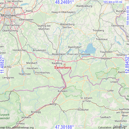
Samerberg GPS coordinates[2]
47° 46' 35.544" North, 12° 11' 29.004" East
| Map corner | latitude | longitude |
|---|---|---|
| Upper-left | 48.24691°, | 11.48827° |
| Center: | 47.77654°, | 12.19139° |
| Lower-right: | 47.30188°, | 12.89452° |
| Map W x H: | 105.1×105.1 km | = 65.3×65.3mi |
| max Lat: | 55.01917° ⇑97.9% North |
| Samerberg: | 47.77654° |
| min Lat: | ⇓2.1% South 47.40724° |
| min Long | Samerberg | max Long |
| 5.92978° | 12.19139° | 14.98853° |
| W 84.5%⇐ | ⇒15.5% E |
Elevation
Elevation of Samerberg is 779 m = 2556 ft, and this is 529.9 m = 1739 ft above average elevation for this country.
| Max E: |
1256 m = 4121 ft | 1% |
| Samerberg | 779 m 2556 ft | |
| Avg. | 249.1 m = 817 ft | |
Min E: |
-5 m = -16 ft | 99% |
See also: Germany elevation on elevation.city.
Geographical zone
Samerberg is located in North temperate zone (between Tropic of Cancer and the Arctic Circle). Distance of this North polar circle is 2088.9 km =1298 mi to North.| Distance of | km | miles | from Samerberg |
|---|---|---|---|
| North Pole | 4694.8 | 2917.2 | to North |
| Arctic Circle | 2088.9 | 1298 | to North |
| Tropic Cancer | 2706.3 | 1681.6 | to South |
| Equator | 5312.3 | 3300.9 | to South |


Nearby cities:
15 places around Samerberg: (largest is in red/bold)
• Altenmarkt
4.2 km =2.6 mi,  274°
274°
• Aschau im Chiemgau
9.8 km =6.1 mi,  89°
89°
• Brannenburg
8.5 km =5.3 mi,  241°
241°
• Burg Unter-Falkenstein
10.3 km =6.4 mi,  218°
218°
• Flintsbach
7.6 km =4.7 mi, 221°
• Frasdorf
7.6 km =4.7 mi,  66°
66°
• Kolbermoor
12.3 km =7.6 mi,  311°
311°
• Neubeuern
3.9 km =2.4 mi, 265°
• Nußdorf am Inn
4.6 km =2.9 mi,  214°
214°
• Prutting
13 km =8.1 mi,  3°
3°
• Raubling
6.2 km =3.9 mi,  284°
284°
• Riedering
7 km =4.3 mi,  10°
10°
• Rohrdorf
2.8 km =1.7 mi,  325°
325°
• Rosenheim
10.3 km =6.4 mi, 329°
• Stephanskirchen
8.6 km =5.3 mi,  357°
357°
Sources, notices
• [Note1] Compared only with cities in Germany existing in our database
• [Src1] Map data: © OpenStreetMap contributors (CC-BY-SA)
• [Src2] Other city data from geonames.org with taken over terms of usage.
• [Src3] Geographical zone / Annual Mean Temperature by Robert A. Rohde @ Wikipedia
