Reimershagen geodata
Reimershagen (Mecklenburg-Vorpommern) is a populated place; located in Germany in Europe/Berlin (GMT+2) time zone. With population of 526 people, there are 9221 cities with bigger population in this country. Compared to other cities in Germany, 88.1% of cities are located further ↓South; 84.3% of cities are located further ←West and 74.7% of cities have higher elevation than Reimershagen. Note1
Administrative division(s):
- Level 1: Mecklenburg-Vorpommern
- Level 3: Landkreis Rostock
- Level 4: Reimershagen


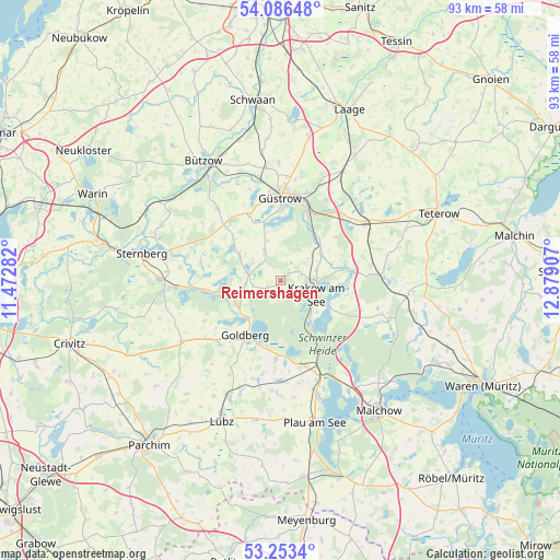
Reimershagen GPS coordinates[2]
53° 40' 19.2" North, 12° 10' 33.384" East
| Map corner | latitude | longitude |
|---|---|---|
| Upper-left | 54.08648°, | 11.47282° |
| Center: | 53.672°, | 12.17594° |
| Lower-right: | 53.2534°, | 12.87907° |
| Map W x H: | 92.6×92.6 km | = 57.5×57.5mi |
| max Lat: | 55.01917° ⇑11.9% North |
| Reimershagen: | 53.672° |
| min Lat: | ⇓88.1% South 47.40724° |
| min Long | Reimershagen | max Long |
| 5.92978° | 12.17594° | 14.98853° |
| W 84.3%⇐ | ⇒15.7% E |
Elevation
Elevation of Reimershagen is 64 m = 210 ft, and this is 185.1 m = 607 ft below average elevation for this country.
| Max E: |
1256 m = 4121 ft | 74.7% |
| Avg. | 249.1 m = 817 ft | |
| Reimershagen | 64 m = 210 ft | |
Min E: |
-5 m = -16 ft | 25.3% |
See also: Germany elevation on elevation.city.
Geographical zone
Reimershagen is located in North temperate zone (between Tropic of Cancer and the Arctic Circle). Distance of this North polar circle is 1433.4 km =890.7 mi to North.| Distance of | km | miles | from Reimershagen |
|---|---|---|---|
| North Pole | 4039.3 | 2509.9 | to North |
| Arctic Circle | 1433.4 | 890.7 | to North |
| Tropic Cancer | 3361.8 | 2088.9 | to South |
| Equator | 5967.8 | 3708.2 | to South |


Nearby cities:
15 places around Reimershagen: (largest is in red/bold)
• Borkow
14.9 km =9.3 mi,  266°
266°
• Dobbertin
8.6 km =5.3 mi,  230°
230°
• Goldberg
10.9 km =6.8 mi,  211°
211°
• Gutow
10.1 km =6.3 mi,  344°
344°
• Güstrow
13.9 km =8.6 mi,  359°
359°
• Hoppenrade
8.9 km =5.5 mi,  45°
45°
• Krakow am See
6.6 km =4.1 mi,  110°
110°
• Kuchelmiß
12.3 km =7.6 mi,  84°
84°
• Lohmen
5.5 km =3.4 mi,  282°
282°
• Lüdershagen
7.8 km =4.8 mi, 47°
• Mustin
13.6 km =8.5 mi, 281°
• Mühl Rosin
10.5 km =6.5 mi,  13°
13°
• Neu Poserin
13.3 km =8.3 mi,  183°
183°
• Prüzen
13.1 km =8.1 mi,  314°
314°
• Zehna
5.5 km =3.4 mi,  333°
333°
Sources, notices
• [Note1] Compared only with cities in Germany existing in our database
• [Src1] Map data: © OpenStreetMap contributors (CC-BY-SA)
• [Src2] Other city data from geonames.org with taken over terms of usage.
• [Src3] Geographical zone / Annual Mean Temperature by Robert A. Rohde @ Wikipedia
