Mustin geodata
Mustin (Mecklenburg-Vorpommern) is a populated place; located in Germany in Europe/Berlin (GMT+2) time zone. With population of 540 people, there are 9140 cities with bigger population in this country. Compared to other cities in Germany, 88.5% of cities are located further ↓South; 81.5% of cities are located further ←West and 80.6% of cities have higher elevation than Mustin. Note1
Administrative division(s):
- Level 1: Mecklenburg-Vorpommern
- Level 3: Ludwigslust-Parchim
- Level 4: Mustin


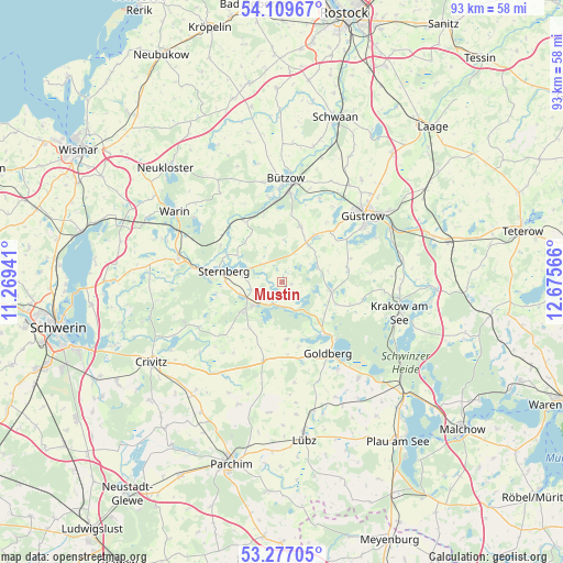
Mustin GPS coordinates[2]
53° 41' 43.512" North, 11° 58' 21.108" East
| Map corner | latitude | longitude |
|---|---|---|
| Upper-left | 54.10967°, | 11.26941° |
| Center: | 53.69542°, | 11.97253° |
| Lower-right: | 53.27705°, | 12.67566° |
| Map W x H: | 92.6×92.6 km | = 57.5×57.5mi |
| max Lat: | 55.01917° ⇑11.5% North |
| Mustin: | 53.69542° |
| min Lat: | ⇓88.5% South 47.40724° |
| min Long | Mustin | max Long |
| 5.92978° | 11.97253° | 14.98853° |
| W 81.5%⇐ | ⇒18.5% E |
Elevation
Elevation of Mustin is 45 m = 148 ft, and this is 204.1 m = 670 ft below average elevation for this country.
| Max E: |
1256 m = 4121 ft | 80.6% |
| Avg. | 249.1 m = 817 ft | |
| Mustin | 45 m = 148 ft | |
Min E: |
-5 m = -16 ft | 19.4% |
See also: Germany elevation on elevation.city.
Geographical zone
Mustin is located in North temperate zone (between Tropic of Cancer and the Arctic Circle). Distance of this North polar circle is 1430.8 km =889.1 mi to North.| Distance of | km | miles | from Mustin |
|---|---|---|---|
| North Pole | 4036.7 | 2508.3 | to North |
| Arctic Circle | 1430.8 | 889.1 | to North |
| Tropic Cancer | 3364.5 | 2090.6 | to South |
| Equator | 5970.4 | 3709.8 | to South |


Nearby cities:
15 places around Mustin: (largest is in red/bold)
• Borkow
3.8 km =2.4 mi,  203°
203°
• Dabel
6.1 km =3.8 mi,  231°
231°
• Dobbertin
10.5 km =6.5 mi,  140°
140°
• Gutow
12.9 km =8 mi,  56°
56°
• Gägelow
5.1 km =3.2 mi,  257°
257°
• Hohen Pritz
9.1 km =5.7 mi,  215°
215°
• Lohmen
8.1 km =5 mi,  99°
99°
• Mestlin
13.1 km =8.1 mi,  193°
193°
• Prüzen
7.8 km =4.8 mi,  31°
31°
• Sternberg
9.8 km =6.1 mi,  281°
281°
• Tarnow
9.8 km =6.1 mi,  17°
17°
• Techentin
12.1 km =7.5 mi,  175°
175°
• Warnow
11.7 km =7.3 mi,  329°
329°
• Witzin
4.6 km =2.9 mi,  312°
312°
• Zehna
11.1 km =6.9 mi,  78°
78°
Sources, notices
• [Note1] Compared only with cities in Germany existing in our database
• [Src1] Map data: © OpenStreetMap contributors (CC-BY-SA)
• [Src2] Other city data from geonames.org with taken over terms of usage.
• [Src3] Geographical zone / Annual Mean Temperature by Robert A. Rohde @ Wikipedia
