Reichenberg geodata
Reichenberg (Bavaria) is a populated place; located in Germany in Europe/Berlin (GMT+2) time zone. With population of 4,004 people, there are 3298 cities with bigger population in this country. Compared to other cities in Germany, 70.6% of cities are located further ↑North; 51.3% of cities are located further →East and 51.1% of cities have lower elevation than Reichenberg. Note1
Administrative division(s):
- Level 1: Bavaria
- Level 2: Regierungsbezirk Unterfranken
- Level 3: Landkreis Würzburg
- Level 4: Reichenberg, Markt


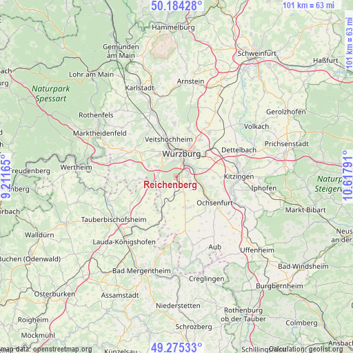
Reichenberg GPS coordinates[2]
49° 43' 54.948" North, 9° 54' 53.208" East
| Map corner | latitude | longitude |
|---|---|---|
| Upper-left | 50.18428°, | 9.21165° |
| Center: | 49.73193°, | 9.91478° |
| Lower-right: | 49.27533°, | 10.61791° |
| Map W x H: | 101.1×101.1 km | = 62.8×62.8mi |
| max Lat: | 55.01917° ⇑70.6% North |
| Reichenberg: | 49.73193° |
| min Lat: | ⇓29.4% South 47.40724° |
| min Long | Reichenberg | max Long |
| 5.92978° | 9.91478° | 14.98853° |
| W 48.7%⇐ | ⇒51.3% E |
Elevation
Elevation of Reichenberg is 234 m = 768 ft, and this is 15.1 m = 50 ft below average elevation for this country.
| Max E: |
1256 m = 4121 ft | 48.9% |
| Avg. | 249.1 m = 817 ft | |
| Reichenberg | 234 m = 768 ft | |
Min E: |
-5 m = -16 ft | 51.1% |
See also: Germany elevation on elevation.city.
Geographical zone
Reichenberg is located in North temperate zone (between Tropic of Cancer and the Arctic Circle). Distance of this North polar circle is 1871.5 km =1162.9 mi to North.| Distance of | km | miles | from Reichenberg |
|---|---|---|---|
| North Pole | 4477.4 | 2782.1 | to North |
| Arctic Circle | 1871.5 | 1162.9 | to North |
| Tropic Cancer | 2923.8 | 1816.8 | to South |
| Equator | 5529.7 | 3436 | to South |


Nearby cities:
15 places around Reichenberg: (largest is in red/bold)
• Eibelstadt
6.2 km =3.9 mi,  98°
98°
• Eisingen
6.8 km =4.2 mi,  297°
297°
• Gerbrunn
7.4 km =4.6 mi,  49°
49°
• Geroldshausen
5.4 km =3.4 mi,  189°
189°
• Giebelstadt
9 km =5.6 mi,  166°
166°
• Höchberg
6.3 km =3.9 mi,  338°
338°
• Kist
5.2 km =3.2 mi,  283°
283°
• Kleinrinderfeld
6.1 km =3.8 mi,  235°
235°
• Randersacker
5.8 km =3.6 mi,  57°
57°
• Sommerhausen
8.6 km =5.3 mi,  111°
111°
• Theilheim
8.7 km =5.4 mi,  73°
73°
• Waldbrunn
8.5 km =5.3 mi,  290°
290°
• Waldbüttelbrunn
8 km =5 mi,  322°
322°
• Winterhausen
7.8 km =4.8 mi, 110°
• Würzburg
7.4 km =4.6 mi,  20°
20°
Sources, notices
• [Note1] Compared only with cities in Germany existing in our database
• [Src1] Map data: © OpenStreetMap contributors (CC-BY-SA)
• [Src2] Other city data from geonames.org with taken over terms of usage.
• [Src3] Geographical zone / Annual Mean Temperature by Robert A. Rohde @ Wikipedia
