Randersacker geodata
Randersacker (Bavaria) is a populated place; located in Germany in Europe/Berlin (GMT+2) time zone. With population of 3,459 people, there are 3649 cities with bigger population in this country. Compared to other cities in Germany, 69.9% of cities are located further ↑North; 50.3% of cities are located further →East and 55.9% of cities have higher elevation than Randersacker. Note1
Administrative division(s):
- Level 1: Bavaria
- Level 2: Regierungsbezirk Unterfranken
- Level 3: Landkreis Würzburg
- Level 4: Randersacker, Markt


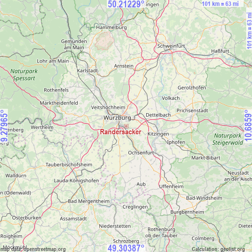
Randersacker GPS coordinates[2]
49° 45' 36.756" North, 9° 58' 57.972" East
| Map corner | latitude | longitude |
|---|---|---|
| Upper-left | 50.21229°, | 9.27965° |
| Center: | 49.76021°, | 9.98277° |
| Lower-right: | 49.30387°, | 10.6859° |
| Map W x H: | 101×101 km | = 62.8×62.8mi |
| max Lat: | 55.01917° ⇑69.9% North |
| Randersacker: | 49.76021° |
| min Lat: | ⇓30.1% South 47.40724° |
| min Long | Randersacker | max Long |
| 5.92978° | 9.98277° | 14.98853° |
| W 49.7%⇐ | ⇒50.3% E |
Elevation
Elevation of Randersacker is 182 m = 597 ft, and this is 67.1 m = 220 ft below average elevation for this country.
| Max E: |
1256 m = 4121 ft | 55.9% |
| Avg. | 249.1 m = 817 ft | |
| Randersacker | 182 m = 597 ft | |
Min E: |
-5 m = -16 ft | 44.1% |
See also: Germany elevation on elevation.city.
Geographical zone
Randersacker is located in North temperate zone (between Tropic of Cancer and the Arctic Circle). Distance of this North polar circle is 1868.4 km =1161 mi to North.| Distance of | km | miles | from Randersacker |
|---|---|---|---|
| North Pole | 4474.2 | 2780.1 | to North |
| Arctic Circle | 1868.4 | 1161 | to North |
| Tropic Cancer | 2926.9 | 1818.7 | to South |
| Equator | 5532.8 | 3437.9 | to South |


Nearby cities:
15 places around Randersacker: (largest is in red/bold)
• Biebelried
7.3 km =4.5 mi,  84°
84°
• Eibelstadt
4.2 km =2.6 mi,  163°
163°
• Estenfeld
7.8 km =4.8 mi,  12°
12°
• Gerbrunn
1.8 km =1.1 mi,  24°
24°
• Geroldshausen
10.3 km =6.4 mi,  214°
214°
• Höchberg
7.7 km =4.8 mi,  290°
290°
• Kist
10.2 km =6.3 mi,  259°
259°
• Reichenberg
5.8 km =3.6 mi,  237°
237°
• Rottendorf
4.7 km =2.9 mi,  40°
40°
• Sommerhausen
7 km =4.3 mi,  153°
153°
• Theilheim
3.5 km =2.2 mi,  101°
101°
• Waldbüttelbrunn
10.3 km =6.4 mi, 287°
• Winterhausen
6.4 km =4 mi, 157°
• Würzburg
4.4 km =2.7 mi,  328°
328°
• Zell am Main
10 km =6.2 mi,  305°
305°
Sources, notices
• [Note1] Compared only with cities in Germany existing in our database
• [Src1] Map data: © OpenStreetMap contributors (CC-BY-SA)
• [Src2] Other city data from geonames.org with taken over terms of usage.
• [Src3] Geographical zone / Annual Mean Temperature by Robert A. Rohde @ Wikipedia
