Würzburg geodata
Würzburg (Bavaria) is a seat of a second-order administrative division; located in Germany in Europe/Berlin (GMT+2) time zone. With population of 133,731 people, there are 67 cities with bigger population in this country. Compared to other cities in Germany, 69.2% of cities are located further ↑North; 50.7% of cities are located further →East and 53% of cities have higher elevation than Würzburg. Note1
Administrative division(s):
- Level 1: Bavaria
- Level 2: Regierungsbezirk Unterfranken
- Level 3: Kreisfreie Stadt Würzburg
- Level 4: Würzburg


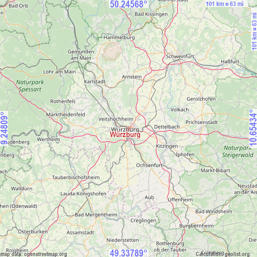
Würzburg GPS coordinates[2]
49° 47' 38.076" North, 9° 57' 4.356" East
| Map corner | latitude | longitude |
|---|---|---|
| Upper-left | 50.24568°, | 9.24809° |
| Center: | 49.79391°, | 9.95121° |
| Lower-right: | 49.33789°, | 10.65434° |
| Map W x H: | 100.9×100.9 km | = 62.7×62.7mi |
| max Lat: | 55.01917° ⇑69.2% North |
| Würzburg: | 49.79391° |
| min Lat: | ⇓30.8% South 47.40724° |
| min Long | Würzburg | max Long |
| 5.92978° | 9.95121° | 14.98853° |
| W 49.3%⇐ | ⇒50.7% E |
Elevation
Elevation of Würzburg is 204 m = 669 ft, and this is 45.1 m = 148 ft below average elevation for this country.
| Max E: |
1256 m = 4121 ft | 53% |
| Avg. | 249.1 m = 817 ft | |
| Würzburg | 204 m = 669 ft | |
Min E: |
-5 m = -16 ft | 47% |
See also: Würzburg elevation on elevation.city.
Geographical zone
Würzburg is located in North temperate zone (between Tropic of Cancer and the Arctic Circle). Distance of this North polar circle is 1864.6 km =1158.6 mi to North.| Distance of | km | miles | from Würzburg |
|---|---|---|---|
| North Pole | 4470.5 | 2777.8 | to North |
| Arctic Circle | 1864.6 | 1158.6 | to North |
| Tropic Cancer | 2930.6 | 1821 | to South |
| Equator | 5536.6 | 3440.3 | to South |


Nearby cities:
15 places around Würzburg: (largest is in red/bold)
• Eibelstadt
8.5 km =5.3 mi,  155°
155°
• Estenfeld
5.5 km =3.4 mi,  45°
45°
• Gadheim
6.6 km =4.1 mi,  330°
330°
• Gerbrunn
3.7 km =2.3 mi,  124°
124°
• Höchberg
5.1 km =3.2 mi,  258°
258°
• Kürnach
8.6 km =5.3 mi,  43°
43°
• Margetshöchheim
7.9 km =4.9 mi,  307°
307°
• Randersacker
4.4 km =2.7 mi,  148°
148°
• Reichenberg
7.4 km =4.6 mi,  200°
200°
• Rimpar
7 km =4.3 mi,  3°
3°
• Rottendorf
5.4 km =3.4 mi,  91°
91°
• Theilheim
7.2 km =4.5 mi,  127°
127°
• Veitshöchheim
6.6 km =4.1 mi, 310°
• Waldbüttelbrunn
7.5 km =4.7 mi,  265°
265°
• Zell am Main
6.2 km =3.9 mi,  289°
289°
In other languages:
- In Spanish: Wurzburgo
- In France: Wurtzbourg
- In Russian: Вюрцбург
- In Chinese: 维尔茨堡
Sources, notices
• [Note1] Compared only with cities in Germany existing in our database
• [Src1] Map data: © OpenStreetMap contributors (CC-BY-SA)
• [Src2] Other city data from geonames.org with taken over terms of usage.
• [Src3] Geographical zone / Annual Mean Temperature by Robert A. Rohde @ Wikipedia
