Eibelstadt geodata
Eibelstadt (Bavaria) is a populated place; located in Germany in Europe/Berlin (GMT+2) time zone. With population of 2,907 people, there are 4085 cities with bigger population in this country. Compared to other cities in Germany, 70.8% of cities are located further ↑North; 50% of cities are located further ←West and 55.8% of cities have higher elevation than Eibelstadt. Note1
Administrative division(s):
- Level 1: Bavaria
- Level 2: Regierungsbezirk Unterfranken
- Level 3: Landkreis Würzburg
- Level 4: Eibelstadt


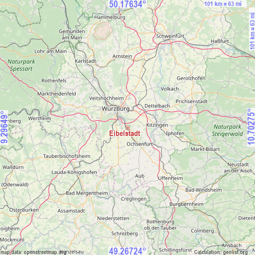
Eibelstadt GPS coordinates[2]
49° 43' 26.112" North, 9° 59' 58.632" East
| Map corner | latitude | longitude |
|---|---|---|
| Upper-left | 50.17634°, | 9.29649° |
| Center: | 49.72392°, | 9.99962° |
| Lower-right: | 49.26724°, | 10.70275° |
| Map W x H: | 101.1×101.1 km | = 62.8×62.8mi |
| max Lat: | 55.01917° ⇑70.8% North |
| Eibelstadt: | 49.72392° |
| min Lat: | ⇓29.2% South 47.40724° |
| min Long | Eibelstadt | max Long |
| 5.92978° | 9.99962° | 14.98853° |
| W 50%⇐ | ⇒50% E |
Elevation
Elevation of Eibelstadt is 183 m = 600 ft, and this is 66.1 m = 217 ft below average elevation for this country.
| Max E: |
1256 m = 4121 ft | 55.8% |
| Avg. | 249.1 m = 817 ft | |
| Eibelstadt | 183 m = 600 ft | |
Min E: |
-5 m = -16 ft | 44.2% |
See also: Germany elevation on elevation.city.
Geographical zone
Eibelstadt is located in North temperate zone (between Tropic of Cancer and the Arctic Circle). Distance of this North polar circle is 1872.4 km =1163.5 mi to North.| Distance of | km | miles | from Eibelstadt |
|---|---|---|---|
| North Pole | 4478.3 | 2782.7 | to North |
| Arctic Circle | 1872.4 | 1163.5 | to North |
| Tropic Cancer | 2922.9 | 1816.2 | to South |
| Equator | 5528.8 | 3435.4 | to South |


Nearby cities:
15 places around Eibelstadt: (largest is in red/bold)
• Biebelried
7.7 km =4.8 mi,  51°
51°
• Frickenhausen
8.9 km =5.5 mi,  131°
131°
• Gaukönigshofen
10.1 km =6.3 mi,  179°
179°
• Gerbrunn
5.7 km =3.5 mi,  355°
355°
• Geroldshausen
8.3 km =5.2 mi,  237°
237°
• Giebelstadt
8.8 km =5.5 mi,  206°
206°
• Ochsenfurt
8 km =5 mi,  145°
145°
• Randersacker
4.2 km =2.6 mi,  343°
343°
• Reichenberg
6.2 km =3.9 mi,  278°
278°
• Rottendorf
7.8 km =4.8 mi,  13°
13°
• Sommerhausen
3 km =1.9 mi,  139°
139°
• Sulzfeld am Main
9.7 km =6 mi,  101°
101°
• Theilheim
4 km =2.5 mi,  33°
33°
• Winterhausen
2.3 km =1.4 mi, 147°
• Würzburg
8.5 km =5.3 mi, 335°
Sources, notices
• [Note1] Compared only with cities in Germany existing in our database
• [Src1] Map data: © OpenStreetMap contributors (CC-BY-SA)
• [Src2] Other city data from geonames.org with taken over terms of usage.
• [Src3] Geographical zone / Annual Mean Temperature by Robert A. Rohde @ Wikipedia
