Bräunlingen geodata
Bräunlingen (Baden-Württemberg) is a populated place; located in Germany in Europe/Berlin (GMT+2) time zone. With population of 6,141 people, there are 2417 cities with bigger population in this country. Compared to other cities in Germany, 96.3% of cities are located further ↑North; 71.6% of cities are located further →East and 97.7% of cities have lower elevation than Bräunlingen. Note1
Administrative division(s):
- Level 1: Baden-Württemberg
- Level 2: Freiburg Region
- Level 3: Schwarzwald-Baar-Kreis
- Level 4: Bräunlingen


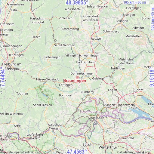
Bräunlingen GPS coordinates[2]
47° 55' 46.452" North, 8° 26' 53.016" East
| Map corner | latitude | longitude |
|---|---|---|
| Upper-left | 48.39855°, | 7.74494° |
| Center: | 47.92957°, | 8.44806° |
| Lower-right: | 47.4563°, | 9.15119° |
| Map W x H: | 104.8×104.8 km | = 65.1×65.1mi |
| max Lat: | 55.01917° ⇑96.3% North |
| Bräunlingen: | 47.92957° |
| min Lat: | ⇓3.7% South 47.40724° |
| min Long | Bräunlingen | max Long |
| 5.92978° | 8.44806° | 14.98853° |
| W 28.4%⇐ | ⇒71.6% E |
Elevation
Elevation of Bräunlingen is 694 m = 2277 ft, and this is 444.9 m = 1460 ft above average elevation for this country.
| Max E: |
1256 m = 4121 ft | 2.3% |
| Bräunlingen | 694 m 2277 ft | |
| Avg. | 249.1 m = 817 ft | |
Min E: |
-5 m = -16 ft | 97.7% |
See also: Germany elevation on elevation.city.
Geographical zone
Bräunlingen is located in North temperate zone (between Tropic of Cancer and the Arctic Circle). Distance of this North polar circle is 2071.9 km =1287.4 mi to North.| Distance of | km | miles | from Bräunlingen |
|---|---|---|---|
| North Pole | 4677.8 | 2906.6 | to North |
| Arctic Circle | 2071.9 | 1287.4 | to North |
| Tropic Cancer | 2723.3 | 1692.2 | to South |
| Equator | 5329.3 | 3311.5 | to South |


Nearby cities:
15 places around Bräunlingen: (largest is in red/bold)
• Bad Dürrheim
11.9 km =7.4 mi,  31°
31°
• Blumberg
11.8 km =7.3 mi,  147°
147°
• Bonndorf
14.7 km =9.1 mi,  212°
212°
• Donaueschingen
4.6 km =2.9 mi,  52°
52°
• Eisenbach
13.9 km =8.6 mi,  284°
284°
• Friedenweiler
14.4 km =8.9 mi,  264°
264°
• Geisingen
15.1 km =9.4 mi,  91°
91°
• Hausen
16.9 km =10.5 mi,  95°
95°
• Hüfingen
3 km =1.9 mi, 98°
• Löffingen
9.3 km =5.8 mi,  236°
236°
• Reichenbach
16.6 km =10.3 mi,  269°
269°
• Tuningen
16.2 km =10.1 mi,  44°
44°
• Unterkirnach
17.8 km =11.1 mi,  339°
339°
• Villingen-Schwenningen
15.1 km =9.4 mi,  12°
12°
• Vöhrenbach
17.3 km =10.7 mi,  320°
320°
Sources, notices
• [Note1] Compared only with cities in Germany existing in our database
• [Src1] Map data: © OpenStreetMap contributors (CC-BY-SA)
• [Src2] Other city data from geonames.org with taken over terms of usage.
• [Src3] Geographical zone / Annual Mean Temperature by Robert A. Rohde @ Wikipedia
