Rehfelde geodata
Rehfelde (Brandenburg) is a seat of a fourth-order administrative division; located in Germany in Europe/Berlin (GMT+2) time zone. With population of 4,600 people, there are 2985 cities with bigger population in this country. Compared to other cities in Germany, 77.9% of cities are located further ↓South; 97.6% of cities are located further ←West and 74.3% of cities have higher elevation than Rehfelde. Note1
Administrative division(s):
- Level 1: Brandenburg
- Level 3: Landkreis Märkisch-Oderland
- Level 4: Rehfelde


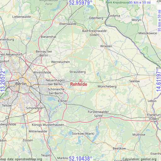
Rehfelde GPS coordinates[2]
52° 32' 3.012" North, 13° 54' 31.824" East
| Map corner | latitude | longitude |
|---|---|---|
| Upper-left | 52.95979°, | 13.20572° |
| Center: | 52.53417°, | 13.90884° |
| Lower-right: | 52.10438°, | 14.61197° |
| Map W x H: | 95.1×95.1 km | = 59.1×59.1mi |
| max Lat: | 55.01917° ⇑22.1% North |
| Rehfelde: | 52.53417° |
| min Lat: | ⇓77.9% South 47.40724° |
| min Long | Rehfelde | max Long |
| 5.92978° | 13.90884° | 14.98853° |
| W 97.6%⇐ | ⇒2.4% E |
Elevation
Elevation of Rehfelde is 66 m = 217 ft, and this is 183.1 m = 601 ft below average elevation for this country.
| Max E: |
1256 m = 4121 ft | 74.3% |
| Avg. | 249.1 m = 817 ft | |
| Rehfelde | 66 m = 217 ft | |
Min E: |
-5 m = -16 ft | 25.7% |
See also: Germany elevation on elevation.city.
Geographical zone
Rehfelde is located in North temperate zone (between Tropic of Cancer and the Arctic Circle). Distance of this North polar circle is 1559.9 km =969.3 mi to North.| Distance of | km | miles | from Rehfelde |
|---|---|---|---|
| North Pole | 4165.8 | 2588.5 | to North |
| Arctic Circle | 1559.9 | 969.3 | to North |
| Tropic Cancer | 3235.3 | 2010.3 | to South |
| Equator | 5841.3 | 3629.6 | to South |


Nearby cities:
15 places around Rehfelde: (largest is in red/bold)
• Altlandsberg
12.7 km =7.9 mi,  285°
285°
• Buckow
11.7 km =7.3 mi,  72°
72°
• Erkner
16.4 km =10.2 mi,  219°
219°
• Grünheide
13.9 km =8.6 mi,  207°
207°
• Hoppegarten
16.5 km =10.3 mi,  263°
263°
• Müncheberg
15.7 km =9.8 mi,  101°
101°
• Neuenhagen
14.9 km =9.3 mi,  268°
268°
• Petershagen
8.3 km =5.2 mi, 259°
• Prötzel
12.6 km =7.8 mi,  24°
24°
• Schöneiche
16.2 km =10.1 mi,  245°
245°
• Strausberg
5.1 km =3.2 mi,  343°
343°
• Waldsieversdorf
11 km =6.8 mi,  85°
85°
• Werftpfuhl
16 km =9.9 mi,  330°
330°
• Werneuchen
16.1 km =10 mi,  312°
312°
• Woltersdorf
13.9 km =8.6 mi,  230°
230°
Sources, notices
• [Note1] Compared only with cities in Germany existing in our database
• [Src1] Map data: © OpenStreetMap contributors (CC-BY-SA)
• [Src2] Other city data from geonames.org with taken over terms of usage.
• [Src3] Geographical zone / Annual Mean Temperature by Robert A. Rohde @ Wikipedia
