Werneuchen geodata
Werneuchen (Brandenburg) is a populated place; located in Germany in Europe/Berlin (GMT+2) time zone. With population of 7,767 people, there are 1996 cities with bigger population in this country. Compared to other cities in Germany, 79.1% of cities are located further ↓South; 97% of cities are located further ←West and 72.8% of cities have higher elevation than Werneuchen. Note1


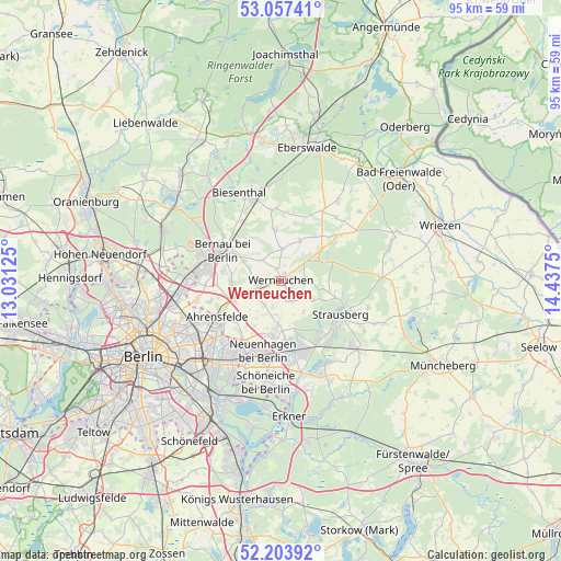
Werneuchen GPS coordinates[2]
52° 37' 57.9" North, 13° 44' 3.732" East
| Map corner | latitude | longitude |
|---|---|---|
| Upper-left | 53.05741°, | 13.03125° |
| Center: | 52.63275°, | 13.73437° |
| Lower-right: | 52.20392°, | 14.4375° |
| Map W x H: | 94.9×94.9 km | = 59×59mi |
| max Lat: | 55.01917° ⇑20.9% North |
| Werneuchen: | 52.63275° |
| min Lat: | ⇓79.1% South 47.40724° |
| min Long | Werneuchen | max Long |
| 5.92978° | 13.73437° | 14.98853° |
| W 97%⇐ | ⇒3% E |
Elevation
Elevation of Werneuchen is 73 m = 240 ft, and this is 176.1 m = 578 ft below average elevation for this country.
| Max E: |
1256 m = 4121 ft | 72.8% |
| Avg. | 249.1 m = 817 ft | |
| Werneuchen | 73 m = 240 ft | |
Min E: |
-5 m = -16 ft | 27.2% |
See also: Germany elevation on elevation.city.
Geographical zone
Werneuchen is located in North temperate zone (between Tropic of Cancer and the Arctic Circle). Distance of this North polar circle is 1549 km =962.5 mi to North.| Distance of | km | miles | from Werneuchen |
|---|---|---|---|
| North Pole | 4154.8 | 2581.7 | to North |
| Arctic Circle | 1549 | 962.5 | to North |
| Tropic Cancer | 3246.3 | 2017.2 | to South |
| Equator | 5852.2 | 3636.4 | to South |


Nearby cities:
15 places around Werneuchen: (largest is in red/bold)
• Ahrensfelde
12.2 km =7.6 mi,  239°
239°
• Altlandsberg
7.5 km =4.7 mi,  183°
183°
• Bernau bei Berlin
11.2 km =7 mi,  297°
297°
• Biesenthal
16 km =9.9 mi,  337°
337°
• Buch
16 km =9.9 mi,  270°
270°
• Falkenberg
14.6 km =9.1 mi, 240°
• Hellersdorf
13.9 km =8.6 mi,  217°
217°
• Hoppegarten
13.7 km =8.5 mi,  199°
199°
• Mahlsdorf
16 km =9.9 mi,  210°
210°
• Marzahn
14.8 km =9.2 mi,  228°
228°
• Neuenhagen
11.8 km =7.3 mi,  194°
194°
• Petershagen
13 km =8.1 mi,  163°
163°
• Rüdnitz
12.3 km =7.6 mi,  323°
323°
• Strausberg
12 km =7.5 mi,  120°
120°
• Werftpfuhl
5 km =3.1 mi,  52°
52°
Sources, notices
• [Note1] Compared only with cities in Germany existing in our database
• [Src1] Map data: © OpenStreetMap contributors (CC-BY-SA)
• [Src2] Other city data from geonames.org with taken over terms of usage.
• [Src3] Geographical zone / Annual Mean Temperature by Robert A. Rohde @ Wikipedia
