Redekin geodata
Redekin (Saxony-Anhalt) is a populated place; located in Germany in Europe/Berlin (GMT+2) time zone. With population of 704 people, there are 8295 cities with bigger population in this country. Compared to other cities in Germany, 77.1% of cities are located further ↓South; 82.9% of cities are located further ←West and 85.8% of cities have higher elevation than Redekin. Note1


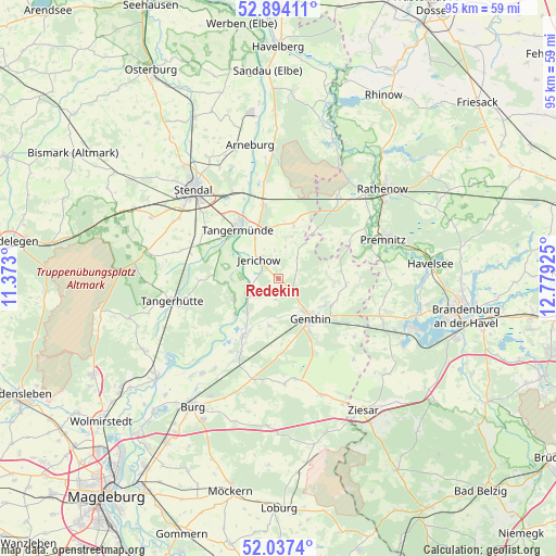
Redekin GPS coordinates[2]
52° 28' 4.224" North, 12° 4' 34.032" East
| Map corner | latitude | longitude |
|---|---|---|
| Upper-left | 52.89411°, | 11.373° |
| Center: | 52.46784°, | 12.07612° |
| Lower-right: | 52.0374°, | 12.77925° |
| Map W x H: | 95.3×95.3 km | = 59.2×59.2mi |
| max Lat: | 55.01917° ⇑22.9% North |
| Redekin: | 52.46784° |
| min Lat: | ⇓77.1% South 47.40724° |
| min Long | Redekin | max Long |
| 5.92978° | 12.07612° | 14.98853° |
| W 82.9%⇐ | ⇒17.1% E |
Elevation
Elevation of Redekin is 33 m = 108 ft, and this is 216.1 m = 709 ft below average elevation for this country.
| Max E: |
1256 m = 4121 ft | 85.8% |
| Avg. | 249.1 m = 817 ft | |
| Redekin | 33 m = 108 ft | |
Min E: |
-5 m = -16 ft | 14.2% |
See also: Germany elevation on elevation.city.
Geographical zone
Redekin is located in North temperate zone (between Tropic of Cancer and the Arctic Circle). Distance of this North polar circle is 1567.3 km =973.9 mi to North.| Distance of | km | miles | from Redekin |
|---|---|---|---|
| North Pole | 4173.2 | 2593.1 | to North |
| Arctic Circle | 1567.3 | 973.9 | to North |
| Tropic Cancer | 3228 | 2005.8 | to South |
| Equator | 5833.9 | 3625 | to South |


Nearby cities:
15 places around Redekin: (largest is in red/bold)
• Bittkau
9.7 km =6 mi,  231°
231°
• Brettin
8.6 km =5.3 mi,  122°
122°
• Ferchland
6 km =3.7 mi,  239°
239°
• Fischbeck
9 km =5.6 mi,  333°
333°
• Genthin
8.8 km =5.5 mi,  140°
140°
• Grieben
8.5 km =5.3 mi,  246°
246°
• Heeren
15.3 km =9.5 mi,  302°
302°
• Jerichow
5.1 km =3.2 mi,  315°
315°
• Kade
16.2 km =10.1 mi,  127°
127°
• Mützel
11.9 km =7.4 mi,  145°
145°
• Roßdorf
10 km =6.2 mi, 116°
• Schlagenthin
13.8 km =8.6 mi,  91°
91°
• Schönhausen
12.8 km =8 mi,  348°
348°
• Tangermünde
10.9 km =6.8 mi, 321°
• Wust
9.7 km =6 mi,  15°
15°
Sources, notices
• [Note1] Compared only with cities in Germany existing in our database
• [Src1] Map data: © OpenStreetMap contributors (CC-BY-SA)
• [Src2] Other city data from geonames.org with taken over terms of usage.
• [Src3] Geographical zone / Annual Mean Temperature by Robert A. Rohde @ Wikipedia
