Brettin geodata
Brettin (Saxony-Anhalt) is a populated place; located in Germany in Europe/Berlin (GMT+2) time zone. With population of 908 people, there are 7494 cities with bigger population in this country. Compared to other cities in Germany, 76.6% of cities are located further ↓South; 84.4% of cities are located further ←West and 86.6% of cities have higher elevation than Brettin. Note1


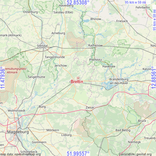
Brettin GPS coordinates[2]
52° 25' 35.076" North, 12° 10' 56.928" East
| Map corner | latitude | longitude |
|---|---|---|
| Upper-left | 52.85308°, | 11.47936° |
| Center: | 52.42641°, | 12.18248° |
| Lower-right: | 51.99557°, | 12.88561° |
| Map W x H: | 95.3×95.3 km | = 59.2×59.2mi |
| max Lat: | 55.01917° ⇑23.4% North |
| Brettin: | 52.42641° |
| min Lat: | ⇓76.6% South 47.40724° |
| min Long | Brettin | max Long |
| 5.92978° | 12.18248° | 14.98853° |
| W 84.4%⇐ | ⇒15.6% E |
Elevation
Elevation of Brettin is 31 m = 102 ft, and this is 218.1 m = 716 ft below average elevation for this country.
| Max E: |
1256 m = 4121 ft | 86.6% |
| Avg. | 249.1 m = 817 ft | |
| Brettin | 31 m = 102 ft | |
Min E: |
-5 m = -16 ft | 13.4% |
See also: Germany elevation on elevation.city.
Geographical zone
Brettin is located in North temperate zone (between Tropic of Cancer and the Arctic Circle). Distance of this North polar circle is 1571.9 km =976.7 mi to North.| Distance of | km | miles | from Brettin |
|---|---|---|---|
| North Pole | 4177.8 | 2596 | to North |
| Arctic Circle | 1571.9 | 976.7 | to North |
| Tropic Cancer | 3223.4 | 2002.9 | to South |
| Equator | 5829.3 | 3622.2 | to South |


Nearby cities:
15 places around Brettin: (largest is in red/bold)
• Bensdorf
10.3 km =6.4 mi,  96°
96°
• Bittkau
14.9 km =9.3 mi,  264°
264°
• Ferchland
12.5 km =7.8 mi,  277°
277°
• Genthin
2.7 km =1.7 mi,  215°
215°
• Gladau
14.9 km =9.3 mi,  204°
204°
• Grieben
15.1 km =9.4 mi,  274°
274°
• Jerichow
13.5 km =8.4 mi,  307°
307°
• Kade
7.7 km =4.8 mi,  132°
132°
• Karow
10.6 km =6.6 mi,  148°
148°
• Mützel
5.3 km =3.3 mi,  185°
185°
• Redekin
8.6 km =5.3 mi,  302°
302°
• Roßdorf
1.7 km =1.1 mi,  88°
88°
• Schlagenthin
7.9 km =4.9 mi,  57°
57°
• Wust
14.7 km =9.1 mi,  341°
341°
• Wusterwitz
15.3 km =9.5 mi,  115°
115°
Sources, notices
• [Note1] Compared only with cities in Germany existing in our database
• [Src1] Map data: © OpenStreetMap contributors (CC-BY-SA)
• [Src2] Other city data from geonames.org with taken over terms of usage.
• [Src3] Geographical zone / Annual Mean Temperature by Robert A. Rohde @ Wikipedia
