Recke geodata
Recke (North Rhine-Westphalia) is a seat of a fourth-order administrative division; located in Germany in Europe/Berlin (GMT+2) time zone. With population of 11,800 people, there are 1390 cities with bigger population in this country. Compared to other cities in Germany, 75.9% of cities are located further ↓South; 82.6% of cities are located further →East and 78.7% of cities have higher elevation than Recke. Note1
Administrative division(s):
- Level 1: North Rhine-Westphalia
- Level 2: Regierungsbezirk Münster
- Level 3: Kreis Steinfurt
- Level 4: Recke


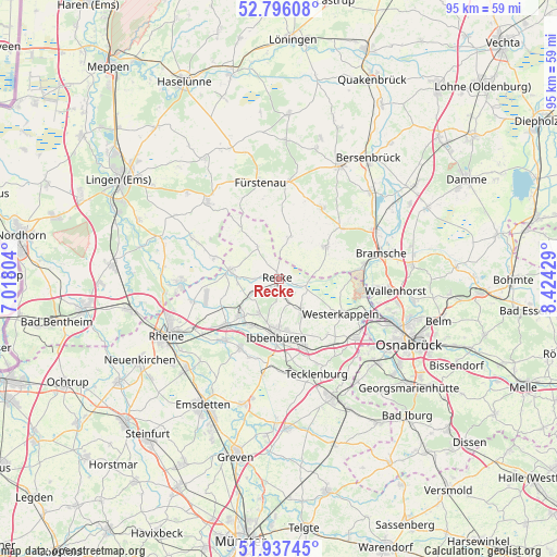
Recke GPS coordinates[2]
52° 22' 7.86" North, 7° 43' 16.176" East
| Map corner | latitude | longitude |
|---|---|---|
| Upper-left | 52.79608°, | 7.01804° |
| Center: | 52.36885°, | 7.72116° |
| Lower-right: | 51.93745°, | 8.42429° |
| Map W x H: | 95.5×95.5 km | = 59.3×59.3mi |
| max Lat: | 55.01917° ⇑24.1% North |
| Recke: | 52.36885° |
| min Lat: | ⇓75.9% South 47.40724° |
| min Long | Recke | max Long |
| 5.92978° | 7.72116° | 14.98853° |
| W 17.4%⇐ | ⇒82.6% E |
Elevation
Elevation of Recke is 51 m = 167 ft, and this is 198.1 m = 650 ft below average elevation for this country.
| Max E: |
1256 m = 4121 ft | 78.7% |
| Avg. | 249.1 m = 817 ft | |
| Recke | 51 m = 167 ft | |
Min E: |
-5 m = -16 ft | 21.3% |
See also: Germany elevation on elevation.city.
Geographical zone
Recke is located in North temperate zone (between Tropic of Cancer and the Arctic Circle). Distance of this North polar circle is 1578.3 km =980.7 mi to North.| Distance of | km | miles | from Recke |
|---|---|---|---|
| North Pole | 4184.2 | 2599.9 | to North |
| Arctic Circle | 1578.3 | 980.7 | to North |
| Tropic Cancer | 3217 | 1999 | to South |
| Equator | 5822.9 | 3618.2 | to South |


Nearby cities:
15 places around Recke: (largest is in red/bold)
• Beesten
16.6 km =10.3 mi,  295°
295°
• Birgte
14.3 km =8.9 mi,  200°
200°
• Dreierwalde
15.4 km =9.6 mi,  254°
254°
• Fürstenau
16.7 km =10.4 mi,  349°
349°
• Hopsten
8.2 km =5.1 mi,  279°
279°
• Hörstel
12.2 km =7.6 mi,  229°
229°
• Ibbenbüren
9.9 km =6.2 mi,  182°
182°
• Lotte
16.3 km =10.1 mi,  125°
125°
• Merzen
14.8 km =9.2 mi,  30°
30°
• Mettingen
7.2 km =4.5 mi,  143°
143°
• Neuenkirchen
9.6 km =6 mi,  56°
56°
• Schapen
11 km =6.8 mi,  288°
288°
• Spelle
17.3 km =10.7 mi,  269°
269°
• Voltlage
7.4 km =4.6 mi,  15°
15°
• Westerkappeln
12.5 km =7.8 mi,  117°
117°
Sources, notices
• [Note1] Compared only with cities in Germany existing in our database
• [Src1] Map data: © OpenStreetMap contributors (CC-BY-SA)
• [Src2] Other city data from geonames.org with taken over terms of usage.
• [Src3] Geographical zone / Annual Mean Temperature by Robert A. Rohde @ Wikipedia
