Hopsten geodata
Hopsten (North Rhine-Westphalia) is a seat of a fourth-order administrative division; located in Germany in Europe/Berlin (GMT+2) time zone. In our database, there are 11009 cities with bigger population. Compared to other cities in Germany, 76% of cities are located further ↓South; 84.9% of cities are located further →East and 82.3% of cities have higher elevation than Hopsten. Note1
Administrative division(s):
- Level 1: North Rhine-Westphalia
- Level 2: Regierungsbezirk Münster
- Level 3: Kreis Steinfurt
- Level 4: Hopsten


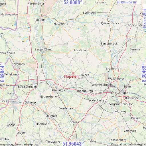
Hopsten GPS coordinates[2]
52° 22' 54.12" North, 7° 36' 5.616" East
| Map corner | latitude | longitude |
|---|---|---|
| Upper-left | 52.8088°, | 6.89844° |
| Center: | 52.3817°, | 7.60156° |
| Lower-right: | 51.95043°, | 8.30469° |
| Map W x H: | 95.4×95.4 km | = 59.3×59.3mi |
| max Lat: | 55.01917° ⇑24% North |
| Hopsten: | 52.3817° |
| min Lat: | ⇓76% South 47.40724° |
| min Long | Hopsten | max Long |
| 5.92978° | 7.60156° | 14.98853° |
| W 15.1%⇐ | ⇒84.9% E |
Elevation
Elevation of Hopsten is 41 m = 135 ft, and this is 208.1 m = 683 ft below average elevation for this country.
| Max E: |
1256 m = 4121 ft | 82.3% |
| Avg. | 249.1 m = 817 ft | |
| Hopsten | 41 m = 135 ft | |
Min E: |
-5 m = -16 ft | 17.7% |
See also: Germany elevation on elevation.city.
Geographical zone
Hopsten is located in North temperate zone (between Tropic of Cancer and the Arctic Circle). Distance of this North polar circle is 1576.9 km =979.8 mi to North.| Distance of | km | miles | from Hopsten |
|---|---|---|---|
| North Pole | 4182.8 | 2599.1 | to North |
| Arctic Circle | 1576.9 | 979.8 | to North |
| Tropic Cancer | 3218.4 | 1999.8 | to South |
| Equator | 5824.3 | 3619.1 | to South |


Nearby cities:
15 places around Hopsten: (largest is in red/bold)
• Andervenne Oberdorf
15.1 km =9.4 mi,  355°
355°
• Beesten
9 km =5.6 mi,  309°
309°
• Birgte
15.2 km =9.4 mi,  167°
167°
• Dreierwalde
8.7 km =5.4 mi,  230°
230°
• Freren
12.4 km =7.7 mi,  341°
341°
• Hörstel
9.4 km =5.8 mi,  187°
187°
• Ibbenbüren
13.7 km =8.5 mi,  145°
145°
• Lünne
13 km =8.1 mi,  294°
294°
• Messingen
13.1 km =8.1 mi,  315°
315°
• Mettingen
14.3 km =8.9 mi,  120°
120°
• Recke
8.2 km =5.1 mi,  99°
99°
• Rheine
15.3 km =9.5 mi, 225°
• Schapen
3.1 km =1.9 mi, 310°
• Spelle
9.3 km =5.8 mi,  259°
259°
• Voltlage
11.6 km =7.2 mi,  60°
60°
Sources, notices
• [Note1] Compared only with cities in Germany existing in our database
• [Src1] Map data: © OpenStreetMap contributors (CC-BY-SA)
• [Src2] Other city data from geonames.org with taken over terms of usage.
• [Src3] Geographical zone / Annual Mean Temperature by Robert A. Rohde @ Wikipedia
