Schapen geodata
Schapen (Lower Saxony) is a seat of a fourth-order administrative division; located in Germany in Europe/Berlin (GMT+2) time zone. With population of 2,444 people, there are 4508 cities with bigger population in this country. Compared to other cities in Germany, 76.2% of cities are located further ↓South; 85.7% of cities are located further →East and 83.7% of cities have higher elevation than Schapen. Note1


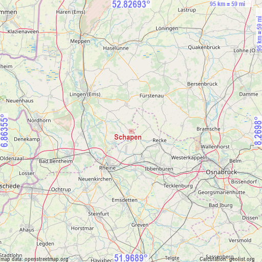
Schapen GPS coordinates[2]
52° 24' 0" North, 7° 34' 0.012" East
| Map corner | latitude | longitude |
|---|---|---|
| Upper-left | 52.82693°, | 6.86355° |
| Center: | 52.4°, | 7.56667° |
| Lower-right: | 51.9689°, | 8.2698° |
| Map W x H: | 95.4×95.4 km | = 59.3×59.3mi |
| max Lat: | 55.01917° ⇑23.8% North |
| Schapen: | 52.4° |
| min Lat: | ⇓76.2% South 47.40724° |
| min Long | Schapen | max Long |
| 5.92978° | 7.56667° | 14.98853° |
| W 14.3%⇐ | ⇒85.7% E |
Elevation
Elevation of Schapen is 38 m = 125 ft, and this is 211.1 m = 693 ft below average elevation for this country.
| Max E: |
1256 m = 4121 ft | 83.7% |
| Avg. | 249.1 m = 817 ft | |
| Schapen | 38 m = 125 ft | |
Min E: |
-5 m = -16 ft | 16.3% |
See also: Germany elevation on elevation.city.
Geographical zone
Schapen is located in North temperate zone (between Tropic of Cancer and the Arctic Circle). Distance of this North polar circle is 1574.8 km =978.5 mi to North.| Distance of | km | miles | from Schapen |
|---|---|---|---|
| North Pole | 4180.7 | 2597.8 | to North |
| Arctic Circle | 1574.8 | 978.5 | to North |
| Tropic Cancer | 3220.4 | 2001.1 | to South |
| Equator | 5826.3 | 3620.3 | to South |


Nearby cities:
15 places around Schapen: (largest is in red/bold)
• Andervenne Oberdorf
13 km =8.1 mi,  4°
4°
• Beesten
5.8 km =3.6 mi,  309°
309°
• Dreierwalde
8.7 km =5.4 mi,  209°
209°
• Freren
9.8 km =6.1 mi,  350°
350°
• Fürstenau
15 km =9.3 mi,  29°
29°
• Hopsten
3.1 km =1.9 mi,  130°
130°
• Hörstel
11.4 km =7.1 mi,  174°
174°
• Lünne
10.1 km =6.3 mi,  289°
289°
• Messingen
10 km =6.2 mi,  317°
317°
• Recke
11 km =6.8 mi,  108°
108°
• Rheine
15.4 km =9.6 mi, 213°
• Salzbergen
16.5 km =10.3 mi,  243°
243°
• Spelle
7.7 km =4.8 mi, 241°
• Thuine
12.5 km =7.8 mi,  333°
333°
• Voltlage
13 km =8.1 mi,  73°
73°
Sources, notices
• [Note1] Compared only with cities in Germany existing in our database
• [Src1] Map data: © OpenStreetMap contributors (CC-BY-SA)
• [Src2] Other city data from geonames.org with taken over terms of usage.
• [Src3] Geographical zone / Annual Mean Temperature by Robert A. Rohde @ Wikipedia
